|
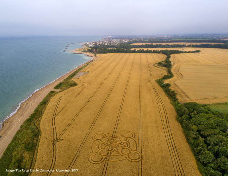
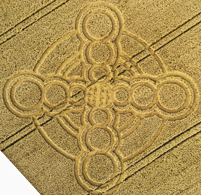
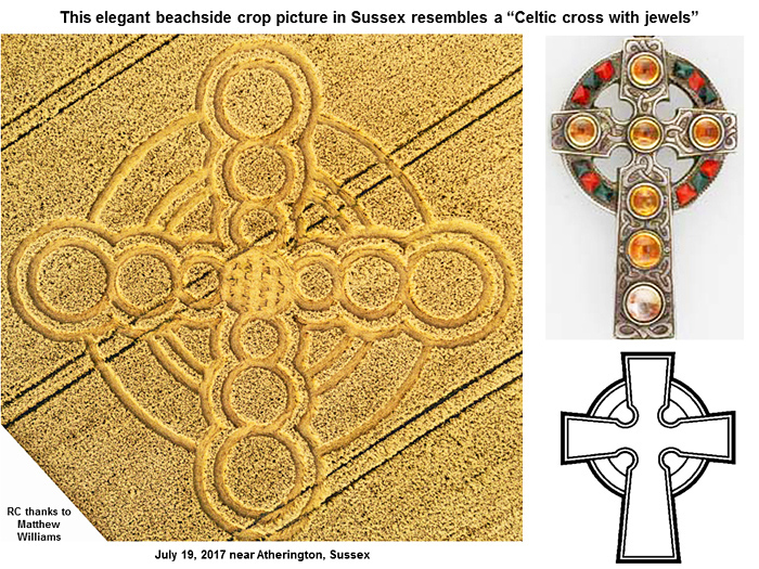
This beautiful "jewel" of a crop picture, found on the beachside
near Atherington in Sussex on July 19, 2017, provides many
interesting aspects to be studied carefully in a factual
scientific fashion: a �jewelled Celtic cross�, the �projective
geometry of a solar eclipse�, or perhaps even the �crosshairs�
of an �instrument landing system�
This new crop picture near Atherington portrays an upcoming
solar eclipse on August 21, 2017 as if it were both a beautiful
�Celtic cross� with �inlaid jewels�, and also the �epicentre� of
some major event, perhaps where different heavenly bodies or
timelines will cross or overlap in a �woven� fashion.
A third possible interpretation might be as the two �crosshairs�
of an �instrument landing system�. One gets the feelings from
studying this crop picture of �beauty� and �precision� and
�power�.
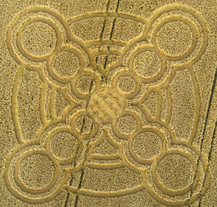
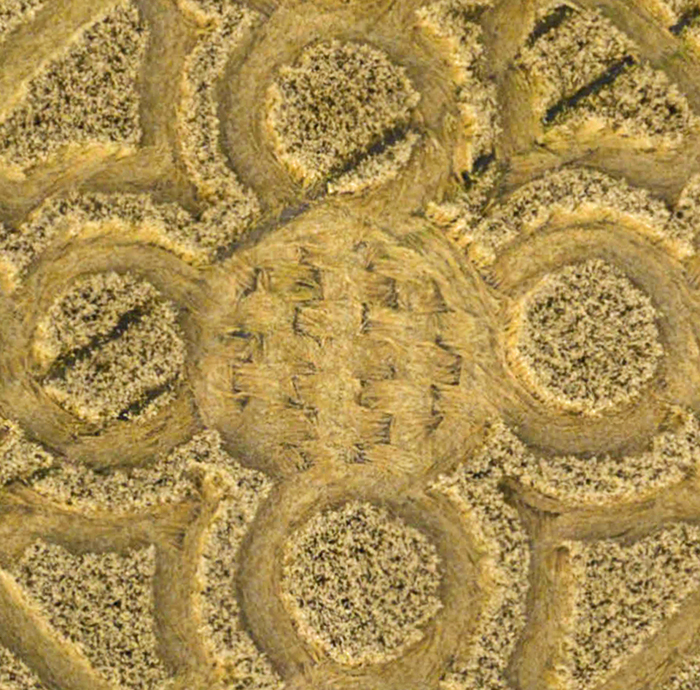
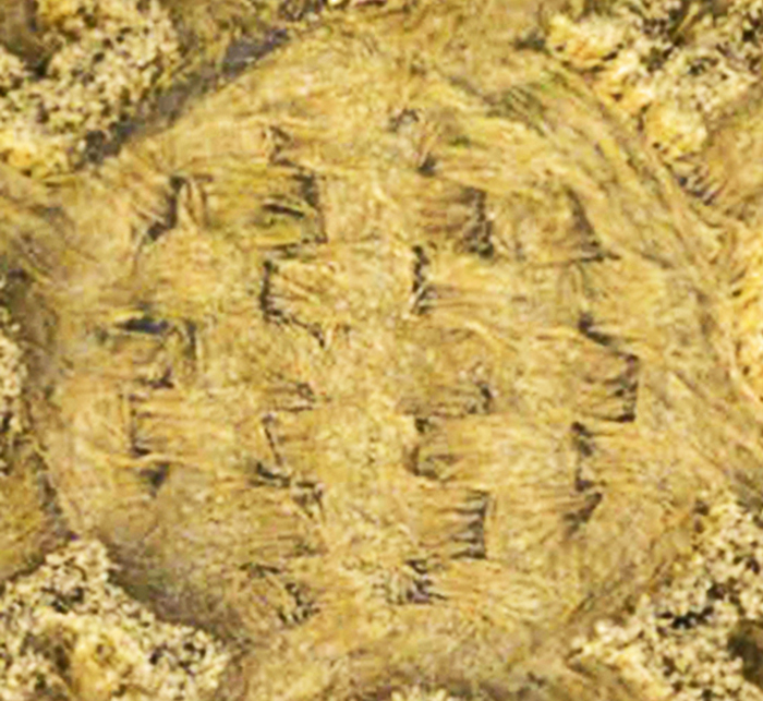
Its central �basket weave�, shown at time 5:10 of Matthew�s
aerial drone video, is truly spectacular, and
would be impossible to create manually on the ground, by any
known methods whatsoever (see
www.youtube.com). Please see some enlarged photos of that
�basket weave� further below on this page.
A series of current news stories from the London mainstream
media, suggesting that these crop pictures are somehow made by
unseen teams of men with �rope and boards�, must be either very
poorly researched, or intentional disinformation (see for
example
surge-crop-circles-caused-drone-users-police-say or
www.bbc.co.uk).
A
beautiful �Celtic cross� with inlaid �jewels�
The
first and most obvious metaphor which might describe this crop
picture would be as a �jewelled Celtic cross�:
The
projective geometry of an upcoming solar eclipse on August 21,
2017
Yet
with a little careful study, we can also see that it might
describe the Sun-Moon-Earth geometry of an upcoming solar
eclipse on August 21, 2017:
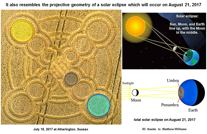
Three
�thin rings� of radius 3, 2 and 2 suggest (32 + 2) = 34 days
from the night of July 18, until a solar eclipse at sunset on
August 21, 2017
Why
did those crop artists draw three �thin rings� as part of their
�Celtic cross� shape? When we study carefully where those
�rings� were drawn, we can see that they lie at relative radii
of 3, 2 or 2 (labelled in black), as defined by the
relative sizes and locations of three large circles of radius
3, 2 or 1 (labelled in blue) nearby:

These three �rings� suggest a total of �3-2� plus �2� or
�34 days� from the evening of July 18 when this crop
picture appeared, until sunset on August 21 as a solar eclipse.
Those three �circles� of decreasing radius likewise suggest a
general countdown through time of �3-2-1-zero!�
A
similar �cross� shape in the landscape not far away, with 3 + 4
�circles� nearby (for 34 days)
How
did the crop artists decide on this particular shape for this
specific field location? Well, when using Google Earth, we can
see a similar �cross� shape in the same orientation not far away
(a large car park), at latitude 50.817o N and
longitude 0.590o W:
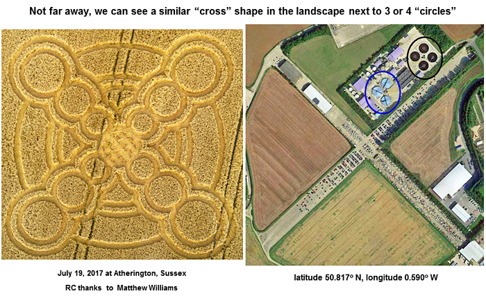
We
can even see two sets of 3 or 4 �circles� near this landscape
�cross� shape, which is precisely how many �circles� were drawn
along each arm of the new crop picture (3 + 4 = 7). So it seems
that they decided on this particular shape and field location,
by studying the Sussex landscape from the air, or by using
aerial maps.
A
�bird-serpent� will be watching the upcoming solar eclipse
Very
close to where the new crop picture was drawn, we can see a
large �bird-serpent� shape. The �eye� of that �serpent� seems to
be �watching� the field location where a �cross� shape was
drawn, symbolic of a solar eclipse on August 21, just 34 days
later (see a dashed yellow line):
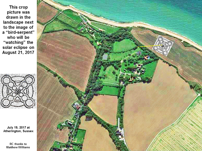
One
might guess that this particular feature was meant to be
humorous.
Other interesting landscape features as seen using Google Earth:
a 5-12-13 right-angled triangle
The complete field in which this crop picture was drawn, at
latitude 50.796o N and longitude 0.580o W,
has the approximate shape of a 5-12-13 or 7-24-25 right-angled
triangle. The crop picture was drawn near its narrow end of
internal angle close to 20o.
Other interesting landscape features as seen using Google Earth:
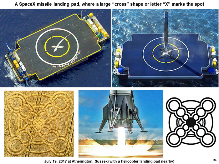
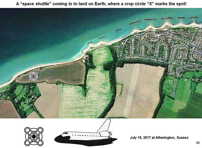
a �space shuttle� coming in to land, with its ILS crosshairs or
�instrument landing system�
This field also resembles the shape of a �space shuttle� coming
in to land from space (or from the dark blue ocean), when it is
studied using Google Earth, with the compass direction South
�up�. The new crop picture in this context would be its intended
landing site: �X� marks the spot.
The detailed shape of this crop picture also resembles two
�crosshairs� from an instrument landing system (or �ILS�), which
is used by a pilot in the �cockpit� (metaphorically where the
crop picture was drawn), for landing any large aircraft or
spacecraft accurately (see
Instrument_landing_system).
There is even the schematic image of a �spaceman� with his
�helmet visor� seen at latitude 50.800o N, longitude
0.590o W, close to the �space shuttle� shape! One is
reminded of the famous David Bowie song: �There�s a starman
waiting in the sky. He�d like to come and meet us, but he thinks
he�d blow our minds� (see
www.youtube.com).
Other interesting landscape features as seen using Google Earth:
two possibly �Christian�
metaphors
When studied on Google Earth with East �up�, we can see the
overlapping image of a �woman with a crown� and �carrying a
child� (a reference to Revelation 12). We can also see
the image of a �smiling man holding a cross, in order to be
saved from snakebite� (a reference to John 3:14).
Interested readers may wish to study all of these subtle
features in greater depth for themselves, to decide whether they
might be relevant.
Red
Collie
(Dr, Horace R. Drew)
P.S.
Many thanks to Matthew Williams for one of his best aerial drone
videos of a new, ET-made crop picture to date. |