|
|
|
Chirton Bottom, Nr Urchfont, Wiltshire. Reported 5th
September.
Map Ref: SU0757955806
This Page
has been accessed

Updated Thursday 24th September 2020 |
|
|
A new crop
picture at Chirton Bottom on September 5, 2020 suggests that something
important may happen close to the winter solstice of December 2020. It
shows in its fallen lay a series of 23 or 24 “ripples”, which resemble
some amazing “ripples in spacetime” that were first reported by
astronomers a few days before.
What are we
to make of this new crop picture? First it seems fairly obvious from
standard astronomical symbolisms, as shown in the slide below, that this
crop picture may describe important events which will take place
close to the winter solstice of December 2020:
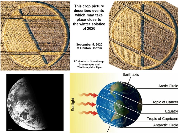
The
“daylight” side of this crop picture points to the southwest in its
local landscape, where our Sun will set in southern England during the
month of December. Could we be receiving here a cryptic message from
unseen time travellers? What might they be trying to tell us?
We cannot be
sure, yet we can see a series of 23 to 24 “ripples” in its
fallen lay, throughout the “daylight” or left-hand side of this crop
picture.Those “ripples” resemble some amazing “ripples in spacetime”
which were first reported by astronomers a few days before (see
www.nature.com or
space-collision-gravitational-waves-reveal-impossible-black-hole-2020):
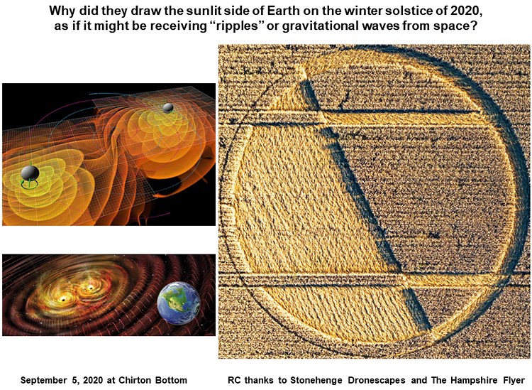
“Seven billion years ago, two black holes crashed into each other and
merged into one enormous black hole. The collision reverberated through
space and time, and its ripples – a phenomenon called
gravitational waves – travelled 16.5 billion light-years to reach Earth
in May of 2019.”
In the crop picture as drawn, we can count 23 or 24 “ripples” overall,
with 4 or 5 of these being broader than the others at lower left. I am
not sure what this detailed feature means.
If we use Google Earth to study the landscape near where this new crop
picture was drawn, we can see (“North” facing up) the schematic
image of a
“man lying on his back”, looking up at the sky, who can “see”
something coming (near latitude 51.301o N, longitude
1.893o W).
Perhaps
there will be more gravity-wave “ripples” still to come? Not being time
travellers, with our human perceptions limited to a narrow “event
horizon”, we will just have to wait and see!
Three other
possible allusions might be:
“Calm before
the STORM” (Donald Trump on October 6, 2017)
“A new era
will begin as worlds collide.” (Mr. Pool on Twitter
twitter.com)
Revelation
6:12. the Sixth Seal.
Best wishes
and safekeeping to you all. Red Collie (Dr. Horace R.
Drew) |
|
Another small crop picture was drawn close to that “ripples on
the winter solstice” image of September 5, two days later on
September 7, 2020
Look
at how the crop artist used a natural
green
image of a “serpent” in the landscape, to drawn the faint
image of an “ouroboros” there:
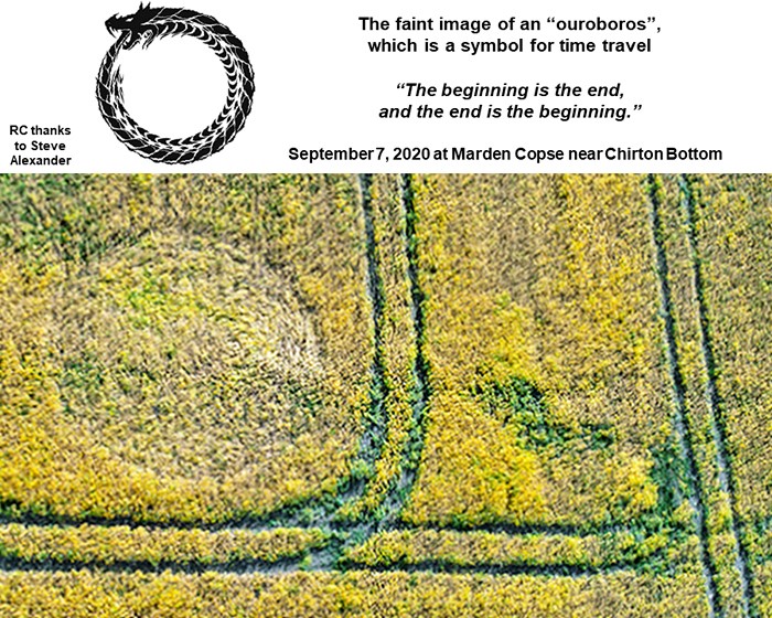
The
“ouroboros” is a symbol for time travel, especially for its
“closed time like curve”. He is suggesting that the large crop
picture drawn nearby is a “time-travel prediction”. Everything
is connected: past to future, and future to past, by a
serpent-like loop of cause and effect which we can scarcely
imagine. |
CLICK HERE FOR THE LATEST CROP
CIRCLE CONNECTOR DVD
|
The mathematical symbol of the difference (not
equal) New crop circle and world divisions because of the differences!
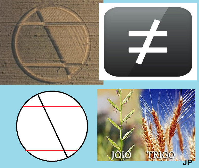
Chirton Bottom nr Urchfont
Wiltshire UK on 9/5/2020 (And the date again forms the code 9-9, in the
following arrangement:
5.2.2 // 9 (9 // 9)
Unexpectedly, a crop circle appears in England, on the eve of the final
harvests of the last remaining fields, with very ripe wheat. I notice
that the aliens took advantage of the lines of the plantation to draw a
determined angle in the cut with the diameter of the crop circle. And
this makes the formation more complex, because we noticed that the areas
of the plantation trails were also marked in the crop circle formation,
alternating light / dark (or lying plants and standing plants). Then,
the image becomes a circle with six geometric areas and a diagonal
intercepted by two semi-lines, which suggests a more detailed
interpretation!
It is not just a circle divided in half by its diameter, but the lines
of the plantation used to form a known mathematical symbol: the
"different" symbol, which is the symbol of the equal cut in half by an
inclined line . And in view of this image, on the eve of the harvest
(the wheat is already quite ripe), we can understand the message
clearly: the world deeply divided into two blocks, in two very different
layers.
What the Christian parable calls chaff and wheat.
And how will the chaff and wheat be differentiated in the plantation?
Only at harvest time, because the wheat is taken away and the chaff is
left behind. And note that the crop circle made this separation, on one
side, lying down (harvested) and on the other, standing up (not
touched).
The world has never really been as polarized as it is now, in extreme
states, climatic states, social states, cultural states. Everything is
very intense, energies and emotions, positions for and against. In the
line of balance we rarely find anyone. But this is the only line that
allows us to still have some awareness and coherence of reason in this
humanity that increasingly reaches the limits of the classic Good x
Evil polarity.
The message is: the differences are striking, the extremes are
irreconcilable. The opposites fighting each other more and more in a
world that distances itself daily from the line of balance, which
justifies its end, by its own hands and unruly ways. I felt a lot of
clarity in that message, right at harvest time, implying the Christian
parable.
Planetary instabilities
Another analysis that stands out in
this new crop circle, of September 5, is the representation of the
Earth, its axis of rotation, and the light-dark sectors, defining the
alternating summer and winter seasons in the northern and southern
hemispheres. The lines of the tropics of Cancer and Capricorn are
marked. In the case of the Tropic of Cancer, the latitude is 23ş27 'N
(23 degrees and 27 minutes north), while in the Tropic of Capricorn the
latitudes are 23ş27' S (23 degrees and 27 minutes south).
In the face of climatic extremes, the series of solar disturbances, the
progressive destruction of nature without restrictions on the part of
capitalist nations, and everything else, we can deduce the relationship
of this crop circle with shakes in the magnetic field and changes in the
rotation pattern that are already affecting directly the climate, in the
aspect of its marked extremisms.
Therefore, the mathematical symbol of "different" ... because today's
times are very different, and they are no longer as they used to be ...
in every way!
Something is
different in the seasons ahead
The first idea here comes from the
combination of the "different" mathematical symbol with a simple model
of the planet Earth in its period of solstices, when the summer and
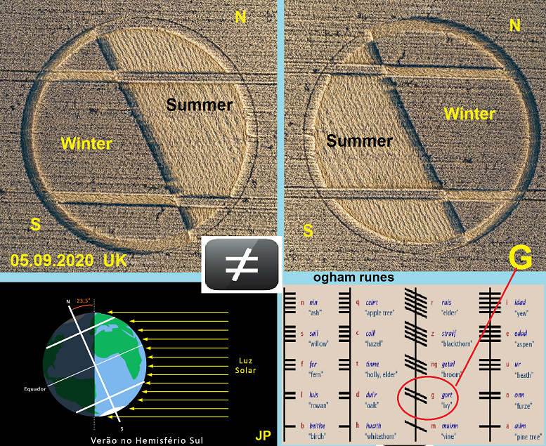
winter seasons begin in the planetary hemispheres.
Now, it's winter in the southern hemisphere and summer in the northern
hemisphere.
The crop circle used the axis of division of sunlight in the solstices
(June 21 and December 21) and inserted the two tropics, Cancer and
Capricorn. And these three lines made up the mathematical symbol of
"different".
The tropics
The tropics of Earth are parallel, that is, lines drawn cartographically
in the east-west direction, parallel to the Equator. As such, they have
specific latitudes. In the case of the Tropic of Cancer, the latitude is
23ş27 'N (23 degrees and 27 minutes north), while in the Tropic of
Capricorn the latitudes are 23ş27' S (23 degrees and 27 minutes south).
Thanks to the solstices and equinoxes, the sun shines its radiation in
different ways throughout the year. In some periods, it is more inclined
to the north, in others, to the south, and there are also times when the
two hemispheres are equally illuminated.
The tropics serve to demarcate the limit of this difference, that is,
the Tropic of Cancer is the most northerly possible area in which the
sun perpendicularly falls. Likewise, the Tropic of Capricorn is the
bottom in the southern hemisphere where perpendicular illumination
reaches its peak.
That is, the crop circle establishes a clear relationship between the
solstices and the two demarcated tropics, and combining this with the
symbol of differences, it seems to be announcing that SOMETHING WILL BE
DIFFERENT in relation to all of this in the next solstice, which will be
the December solstice, day 21, when summer begins in the southern
hemisphere and winter in the northern hemisphere.
Well, other numerical coordinates are interesting. For example, friend
Renata Curcio noticed that the sum of the latitudes of the tropics, 23 °
27 ', is precisely the date of the crop circle: 23 adds 5, 27 adds 9,
and the day of the crop circle? 05.09.
And I night that the complete date adds 5 + 9 + 2 + 2 = 18. And in
exactly 18 days, another new season begins, spring in the south and
autumn in the north!
"Different" seasons are already a reality. And the extremes too. But
this crop circle does not seem to me to say something that is already
obvious and obvious to everyone. He is announcing something "different"
ahead, in the course of changing seasons.
And as we are suffering instabilities of all kinds, and recently the
Earth has been receiving strong solar storms, plus the fact that
scientists predicted a powerful solar storm, like the one that happened
in 1859, this crop circle may be revealing the Earth suffering a bombing
of solar energy soon.
Curiosity The "different" symbol is the same as the GORT symbol in the
Ogham alphabet, equivalent to the letter G.
Ogham was an alphabet originally used in Old Irish, and later in Old
Irish and Picto on a smaller scale. Ogam is sometimes called the "Celtic
alphabet of trees. The Gort rune means the IVY plant and represents the
fields in general.
And like any climbing plant, Ivy may be signifying the need to adapt to
the altered climate of the present-future.
This also seems quite obvious!
Jonas Passos (05.09.2020)
Design UFO on radar
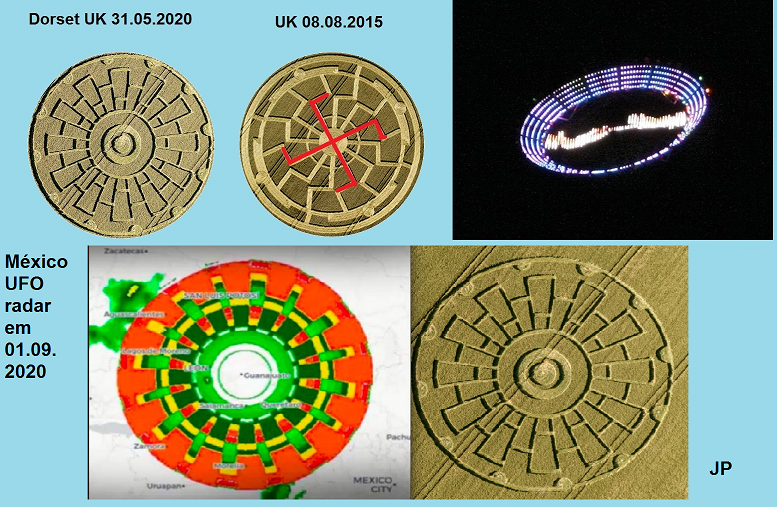
Who knew about that UFO that
appeared for a few seconds in front of a weather radar in Mexico, on the
first of September? Well, I knew I had already seen that image, and a
researcher discovered a crop circle with the same structure as the UFO.
A crop circle from 31 May in Dorset
UK. And one of my interpretations of this crop circle was that it
exhibited a UFO and its mechanisms. In fact, another video in the
article published below shows that the object rotated on the radar
image! Anomaly nothing. It was an extraterrestrial UFO!
Read more here:
o-ufo-que-apareceu-no-radar-de-meteorologia-do-mexico-foi-previsto-num-crop-circle
Symmetries of earthquakes in 06.09 and the recent crop circle
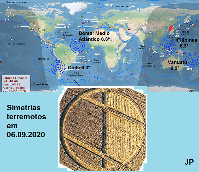
My friend Renata Curcio brought to
my attention a study that verified points of symmetry of earthquakes of
close degrees (above 6.0 °) yesterday, September 6th. Two earthquakes in
the Western or Western Hemisphere, Chile and Dorsal Middle Atlantic,
respectively 6.3 ° and 6.6 °. And on the other side of the world, the
Philippines, 6.3 ° and Vanuatu Islands, 6.2 °, both in the Eastern or
Eastern hemisphere. It is interesting to note that it was on a 6th, with
four earthquakes on a 6th scale, two of them, of the same value (6.3 °)
in opposite hemispheres.
And she pointed out the symmetry proposed in the crop circle of one day
earlier, September 5th. I myself believe in the predictive power of crop
circles, and the suggestion that one of its interpretations could be
these symmetrical results of earthquakes in the two hemispheres,
moreover, marked by the crop circles in the light and dark colors and
the axis of the solstices, both tropics of Capricorn, etc. These
symmetries have happened before, and are relatively rare.
Recalling that the same symmetries happen, for example, in the
phenomenon of cyclones, in the lines above and below the Equator.
The stations themselves are
symmetrical and opposite. Symmetrical when equinoxes enter (from the
term "equi", equal) that is, springs and autumns with a similar climate
in the two hemispheres, North and South, while the solstices show
opposite seasons in the same hemispheres, summer and winter, all these
seasons alternating with over the months.
Anyway, I believe that the strongest message of this latest crop circle
is the DIFFERENT sign, something that becomes different in relation to
weather patterns and other planetary patterns ahead. perhaps already
scheduled for the next equinox (23.09) and solstice (21.12) with changes
of season. In fact, 2020 is already DIFFERENT from all previous years.
This is a fact.
Jonas Passos (07.09.2020)
Drastic change in temperatures, climatic
extremities and the last crop circle
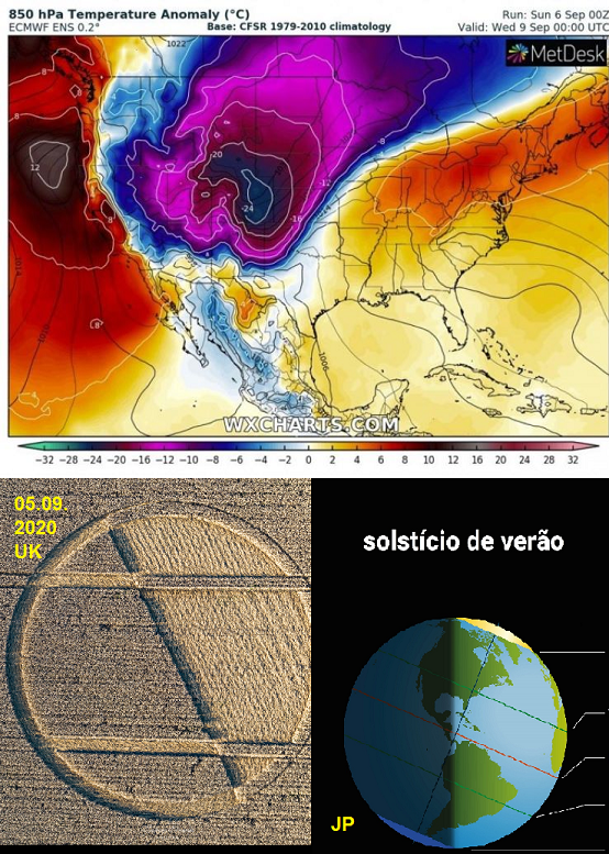
This news confirms part of the
interpretation of that last crop circle, with the mathematical symbol
"different", and also the two hemispheres of the Earth separated in
winter and summer (solstices). The sudden variation in temperature (35 °
C) happens in the USA because of the movement of a cold front, causing
the temperature to fall in 36 hours in such variation.
The forecasts are for the Colorado region in the coming hours, valid
until September 9th. These sudden changes in temperature, with records
like this, 35 degrees of variation, are harmful to agriculture and human
health, gradually undermining vitality. What's going on with the
weather?
Neither global warming nor mini-glaciation, but both at the same time.
Heat waves followed by sudden drops in temperature, or cold waves
interrupted by periods of intense heat, confusing what is summer and
what is winter. Therefore, the DIFFERENT symbol on that crop circle.
Because the seasons are no longer the same. Neither the climate, nor the
planet, nor humanity.
The new-normal? And how will it end? Or is it that, each year, we will
have to enter different "new normals" that are nothing more than serial
abnormalities? The big problem in all of this is that all of these
climate changes are forcing creatures to adapt all the time, and this
continued adaptation sucks up a lot of vital energy in the process. Or,
in other words, humanity is gradually becoming ill under so much
climatic instability. Nature is a source of life, but in this state of
chaos, it becomes a deadly factor.
Jonas Passos (08.09.2020) |
|
As the time for Comet A comes closer we should expect fewer crop circles
each season. This formation reveals the area which will be affected by
Comet A. The middle portion between the northern and southern boundaries
will experience the impact of the nucleus, plus the major fragments,
besides the minor fragments, particles, dust, the debris trail, and the
gases released into the atmosphere. Winds will scatter the dust and
gases over a wide area. Since prior circles suggest that Comet A's
trajectory will be from the northwest to the southeast to strike in the
Atlantic Ocean at night, the two boundary lines should be slanted
downward from left to right.
The impact will be somewhat above the Equator, resulting in the northern
boundary being closer to the North Pole than the southern boundary is to
the South Pole.
Kenneth Heck |
|
 |

FOR VISITING THE CROP
CIRCLES.
|
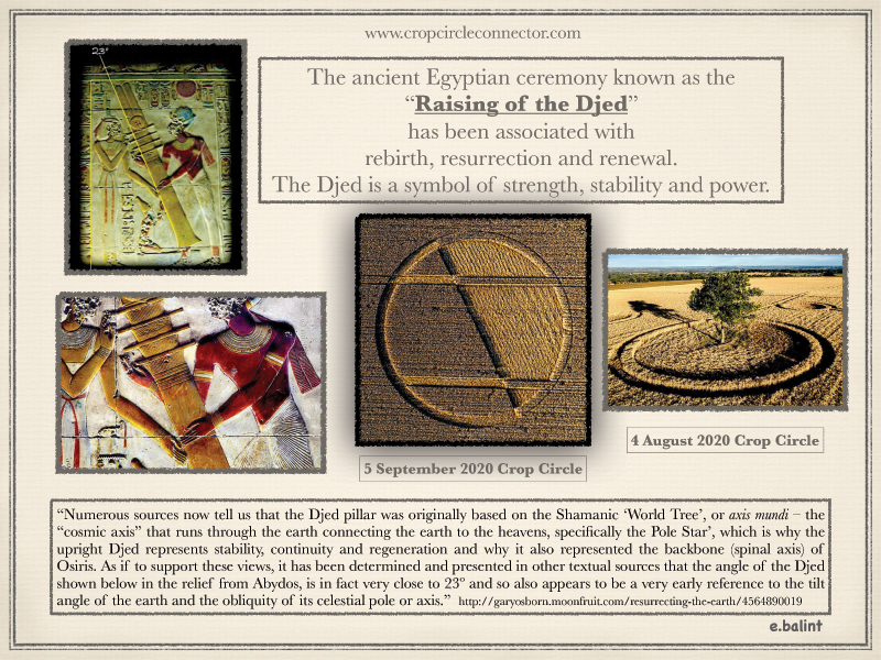
CHIRTON BOTTOM CROP CIRCLE 5th
SEPT 2020
A very interesting late circle
in many ways....the ‘Half’ is clearly shown, of course, in two ways
but it does seem to flag the tilt of the earth, as the Egyptian Djed
pillar illustration suggests. The Midwinter Solstice seems to be
demonstrated looking at how the design was placed but there are only
two occasions in the year when there is balance and harmony,
Egyptian Ma’at, and that is, of course, at the Equinoxes. This might
be when the symbolic Djed pillar is upright and the cross lines on
the Djed pillar line up with lines of latitude on the Earth, and the
rays from the sun, when sunrise is due East everywhere on Earth.
The most famous ancient site in
mainland Britain that is known to demonstrate the solstices is
Stonehenge as this is aligned to the Summer Solstice Sunrise and
hence the Winter Solstice Sunset in the south west and the latter
would seem to be the important one as the experts now tell us that
this was the festival time at Stonehenge with no great activity in
the area at the Summer Solstice. But recent discoveries there show
that thousands of years before the henge was built post holes were
dug and these were aligned East to West so marked the sunrise /
sunset at the Equinoxes. The earliest location so far discovered at
this World Heritage Site is Blick Mead which lies to the east of the
famous monument and is thousands of years older. So from the
Stonehenge circle site at the Equinoxes a person would see the sun
rise almost over Blick Mead. From Blick Mead an ancient observer
would see the sun set over the later site of the henge and stone
circle.
As noted in previous comments
sunrise positions on the horizon were very important to the Ancient
Egyptians particularly Midwinter Solstice sunrise in the Thebes
area, and clear causeway markings of half way sunrise position at
the famous Giza pyramid site, along with other half way messages at
that site. The circle makers have demonstrated this year, last year
and in previous years, the importance of middle or half bearings
between the cardinal directions of north, south, east and west. So
they often flag bearings of 045, 135, 225 and 315 degrees. The
Bavarian crop circle of 26th July this year has a 135
degree bearing which goes to Thebes but in doing so it tends to
highlight famous oracle sites in Ancient Greece. Even the famous
Dodona and Delphi sites are only a relatively short distance either
side of this Great Circle bearing line. Epidaurus the major healing
centre of the God Asclepius, associated with snakes (see- Rod of
Asclepius), is effectively right on the bearing line from this
Bavarian formation. This bearing crosses Crete next to ancient
Knossos and right next to the famous Zeus cave, with Neolithic
origins – 134.91 degrees and about 1840 km from the Bavarian crop
circle this year. There were previous crop formations in close
proximity to this years’ event. Crop circles in northern Germany e.g
Brandenburg 2016, has a 135 bearing that, of course, does not go to
Thebes. That 135 bearing went to Cypress, Paphos, which was another
famous oracle centre and sacred site of the ancient world.
This Chirton crop circle has a
Longitude of about 1.8928W and this closely compares to two other
formations this year , Wilton 17/6/20 at 1.8823W and Patney Bridge
8/8/20 at 1.8950W. The latter design, Patney Bridge, at almost
exactly the same longitude as Chirton, is a clear geometric design
but further north than Chirton. By interpreting this design to
improve symmetry and balance by rotating the squares we find the
angles 0f 45 and 135 degrees so important in ancient Egypt and in
interpreting the messages in many crop formations. The Chirton
longitude of about 1.8928 degrees west is not the longitude of the
Stonehenge circle centre, which is about 1.8261W but very close
(about 0.066 of a degree) and if these crop circle longitudes which
average about 1.890W are an important north / south line it is
marked at the Stonehenge latitude by numerous barrows at ‘The
Coniger’ and ‘Fore Down’ barrow cemeteries just north of
Winterbourne Stoke. With so many ancient sites in the Stonehenge
area it is, however, not possible to be certain that some may have
been placed as part of a geometric design.
But why would the circle makers
want to flag a longitude line very close, but not on, the Stonehenge
site longitude if their intention was to draw attention to the
solstice orientated Stonehenge site’s links to the design of the
circle they created? Why not put it on the Stonehenge longitude ?
They may have been
demonstrating the Egyptian Shen ring, a circle with a tangent line
along one side and the Wilton formation may be showing this with an
offset circle and a cross, some might say Templar, in the middle.
The Shen ring is very similar to the earlier Rod and Ring symbol of
Ancient Mesopotamia which has been much discussed but with no clear
answer as to what it really means. In Egyptian art the circle of the
Shen often encircles the Sun and was believed to be a protective
symbol with links to cycles of time. The cartouche derives from it.
The first UK crop circle this
year was at Rocky Hill Kingsdon, 26/5/20 and the longitude was the
longitude of Glastonbury Tor but not exactly the top of the Tor
slightly to the east. So this might have also been planned as an
example of the Shen principle, important sites next to or near a
bearing line but not exactly on it. The 045 degree bearing from this
Kingsdon formation goes next to an ancient earthworks just north of
Trowbridge town centre. The longitude of Trowbridge is flagged again
this year by two crop formations, Cley Hill 11/7/20 and Mid Wilts
Way, Warminster 30/5/20.
Last year it was commented that
the town longitude was flagged by three crop formations and a
general alignment over 500 km from France of five separate
formations, one repeated this year at Yarnbbury Castle on 26/7/20,
the same day as the Bavaria formation with its 135 bearing to
Thebes. Half a circle is 180 degrees plus 135 = 315 degrees, the
azimuth of 500km alignment from France last year.
Preston comments 2019
Glastonbury and Trowbridge are on the Michael
Line through southern Britain.
Mike Stewart September 2020
ADDENDUM TO COMMENT ON CHIRTON BOTTOM CROP CIRCLE OF 5TH SEPT 2020
Anyone seriously interested in
the crop circle phenomena, why do we get them and what do they mean,
may have come across the comments previously made about the clearly
geometric positioning of some formations using the latitude and
longitudes of their chosen sites. This can often be shown to be
flagging very ancient remains from thousands of years ago.
In the previous comment on this
particular Chirton crop formation it was suggest that because of the
close longitude similarity of three separate crop formations this
year e.g. Wilton 17th June(No10), Patney Bridge 8th
August(No 34) and now Chirton 5th September No 36), the
circle makers, whoever they are, might be flagging a longitude line
about the average of the longitude of these three formations, which
is 1.89 degrees west of the Greenwich meridian.
Why would the
circle makers want to highlight this particular north / south
longitude line this year? And does it relate to the nearby
Stonehenge ?
As noted before this might
relate to an ancient belief, or knowledge, of an important site
being passed by a line and this may be represented by the Shen Ring
of Ancient Egypt and the Rod and Ring symbol of ancient Mesopotamia
. But is there any real evidence that some people in ancient Britain
knew there was a meridian of significance just west of Stonehenge
and that they hence wished to flag this with burial sites or
earthworks? A line that is now being flagged this year by crop
formation locations aligned north / south at about 1.89 degrees west
of Greenwich ?
There is some
evidence that this is the case...
historicengland.org.uk
Anyone at all interested in
trying to solve the crop circle mystery can look and see what the
experts today have recorded about this ancient site, called The
Coniger, at the latitude of the Stonehenge monument and a short
distance to the west. They record that there is an ancient alignment
of burial sites north / south and earthworks aligned east / west at
this historical site and it lies exactly on the average longitude of
the crop circles sites mentioned and all created this year....1.89
degrees west.
A coincidence? Is this just a
coincidence or are the crop formation makers once again
demonstrating that the locations of crop circles and many ancient
sites are indeed geometrically linked ? On its own this could be
just a coincidence but as has been commented on before when many
strange coincidences occur this suggests the presence of a design,
an ancient design now being flagged by crop formation locations.
So the longitudes of these
three crop formations do give us a north south line that is indeed
marked by a significant ancient site, with an ancient north/south
layout, at the Stonehenge latitude, but what about the latitudes of
these three formations up and down this north / south line, is there
anything to be deduced from where on this line the crop formations
were created.
There is clear
evidence that this is the case...
The first UK crop circle this
year at Kingsdon had a longitude that matched Glastonbury Tor, but
not quite the top. The 045 degree bearing from that formation goes
next to the ancient earthworks just north of Trowbridge, and the
latitude line from the Patney Bridge formation( No 34) goes to the
Hilperton district of Trowbridge and just south of the same
earthworks. Historic England entry refs
historicengland.org.uk
The Chirton formation
latitude(No 36) goes west to cross the Michael line in the southern
outskirts of Trowbridge with no apparent marker point, that remains
today anyway, but the Wilton formation (No10) latitude goes west to
cross the Michael Line at a very significant spot. This is
Burrowbridge with its famous Mump with St Michael church ruins on
top. This is a very important Michael Line marker point.
Another coincidence seems
highly improbable with the Burrow Mump as a key site on the Michael
Line like Glastonbury Tor, also highlighted by the crop formations
this year as noted before. The church ruins on the Mump are quite
recent but excavations have found items from Roman times and the
Mump may have had much earlier significance. Once again the latitude
line from the Wilton crop formation (No10), at about 51.6076 North
passes the Mump a fraction to the south, but well within the
village, so this seems to be another example of the Shen Ring, Rod
and Ring principle of ancient sites close to an important bearing
line.
It is worth noting that the
crop formation near Ogbourne St George on 25th June this
year (No13) at Smeathe’s Plantation was placed very close to the
Michael Line through southern Britain, the route of this line being
calculated by the positions of Glastonbury Tor and Burrow Mump. From
Burrow Mump Michael church ruins to the same on the top of
Glastonbury Tor is a bearing of about 61.42 degrees from True north.
From the Mump to the Ogbourne St George Crop circle is about 60.77
degrees so pretty close just to the north of the line. The Michael
line at 61.42 degrees from the Mump goes through the area just to
the north of the Ogbourne St George village church building, but on
church lands, it seems, and a fraction south of an ancient track
called Woolmer Drove Track on the Ordinance Survey. So this track is
an ancient route where the Ancient Ridgeway also converges at the
village. This church is dated to the 12th Century but
with believed pre-Norman origins and like many very early churches
was probably built on a pre-Christian sacred site and at a meeting
point from the distant past. These meeting points of ancient routes
can often be found close to the Michael Line through southern
Britain. This one is being flagged by the Smeathe’s Plantation Crop
Circle of the 25th June this year. With all the bearings
that point to Trowbridge, this year and last year, that location
would seem to have also been an ancient significant meeting point.
So the sequence of crop circle location generated bearing links goes
from Glastonbury Tor south to the Kingsdon crop circle then 45
degrees to the Trowbridge ancient enclosure then south to the
Warminster and Cley Hill crop circles. Cley Hill is a regular crop
circle location. Do the bearing links stop in this Warminster
area?....No, they do not...
Using the already well
established 45 degree bearing angle( see previous comments and the
Ancient Egypt Giza link) and taking a 45 degree square to say
Google, or any maps, this bearing line from Warminster, North East
-045 degrees from True north, does possibly go to another
interesting crop formation location this year. This is the Barbury
Castle formation of 14th June (No9), south of Wroughton
and Swindon. A detailed look at the latitude and longitude of this
crop design and comparing that with the latitudes and longitudes of
the two crop circles this year close to Warminster and Cley Hill
revealed some very interesting facts. The bearings to and from these
sites are very close to 45 degrees if going North East, and 225
degrees if going South West from Barbury Castle, but not quite
exact. However it is very clear that these 3 crop formations were
carefully placed to demonstrate that they were linked
Barbury Castle(No9) ...to....Mid Wilts Way
Warminster (No 4) 30th May... 224.5 degrees ...44.9km
Barbury Castle(No9)...to...Cley Hill nr
Warminster(No20) 11th July....225.5
degrees.............45.1km
This means the average bearing
was 225.0 degrees...a half bearing between the cardinal points again
as discussed before, this time south west. To confirm the connection
the distances average 45km.(See Patney Bridge comments for another
example of what the Circle Makers were doing this year)
More
‘coincidences’...? or a design ?
So the crop circle geometry has
moved us from Warminster (something of a hotspot for strange
reported happenings it seems) to Barbury Castle next to Burderop
Down Celtic Field System ( or landscape markings?) where we take the
Ancient Ridgeway, about 135 degrees to pass to the north of the
Ogbourne St George crop circle this year (No 13) and cross the
Michael Line just west of the village. This crop circle (No13) was
placed between these two bearing lines.
As the German
farmer said this year standing next to the massive Bavarian Crop
formation (No28) with its links to Ancient Egypt
‘It must be
students I suppose, but don’t know how they did in the dark
overnight’....! !
Mike Stewart 15th September 2020 |
|
Could this design also be giving
the world a subliminal message regarding "Q" and Q's role coming into
prominence before or at Winter Solstice December 21st ?
Barbara T Canada |
|
Through our focused thoughts we can define new, better pathways for the
development of our civilization!
Crop circle from
5
September
2020
at
Chirton Bottom, near Urchfont, Wiltshire,
UK
According to the Mayan Dreamspell calendar Tzolkin, 5 September 2020 is a
day with the Solar Seal Yellow Sun with Tone 4, in the Red Earth wavespell,
in the Yellow Castle with major energy Yellow Sun.
In
my opinion, on the formation are depicted following energies:
Tone 4 – the Selfexisting Tone of Form
Yellow Sun – Enlightenment, Universal Fire, Life
Red Earth – Evolution, Navigation, Synchronization
Yellow Seed – Targeting, Awareness, Flowering
Red Dragon – Birth, Nurturing, Being
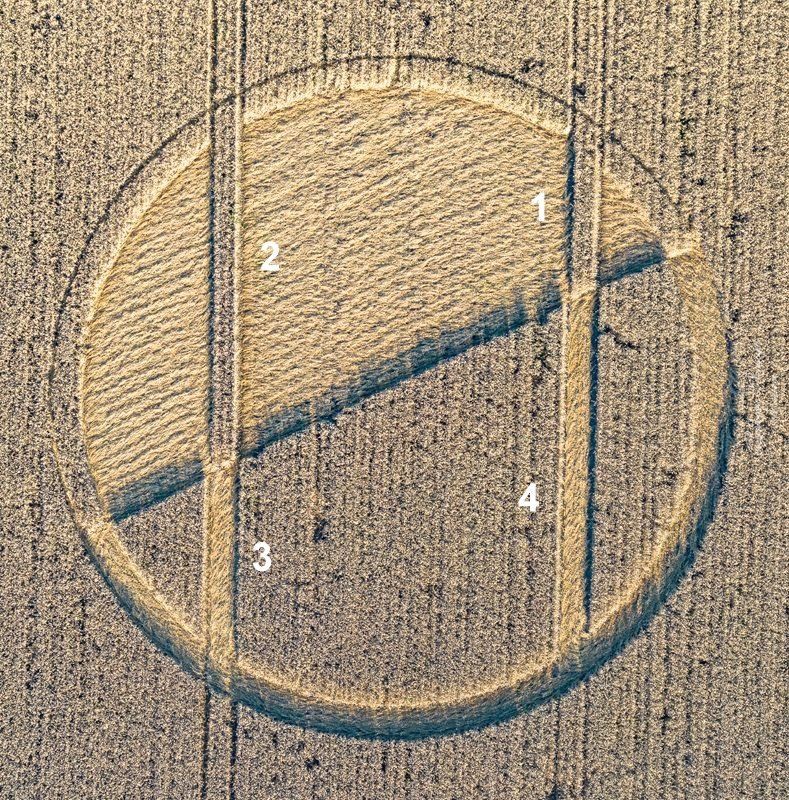
The big outer circle represents the Earth and symbolizes the energy RED
EARTH.
This big circle is divided in two halves – one dark and one bright.
The bright semicircle represents the energy YELLOW SUN.
The dark semicircle represents the energy RED DRAGON – the Occult Teacher
of the Yellow Sun.
The Yellow Sun is Solar Seal No. 20. This is the energy with the highest
vibrations.
Tone 4, the Tone of Form, helps us to create Thought-Forms, which shall be
materialized.
In the Yellow Castle we can use the highest energy Yellow Sun to shape
Thought-forms for the creation of the desired reality.
Yellow Sun with Tone 4 shows us that at the bottom of Life is the balance
between Light and Dark.
These are the energies Yin and Yang, which are seemingly opposite, but they
are
complementary, interconnected and interdependent.
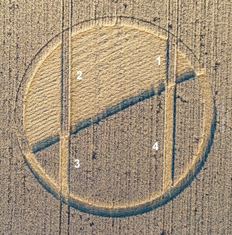
In the bright semicircle are depicted 24 “ripples”.
The number 24 symbolizes the energy Yellow Seed – the Occult Teacher of the
Red Earth. Kin 24 in Tzolkin is with the Solar Seal Yellow Seed.
These “ripples” depict the energy waves, which we create through our
Thoughts. With “Thoughts” I summarize our thoughts, ideas, words, dreams,
targets, intentions etc.
On the crop circle is shown the process of Co-Creation, how we through our
Thought-Forms create the desired reality.
In
our Consciousness (in the bright semicircle) we create two thought-forms –
the paths 1 and 2.
Thank to the principle of Reflection our thought-forms are
projected in the dark space and there they appear, firstly on energy level,
as the paths 3 and 4.
Red Dragon, the energy of Birth, reacts to our energy
impulses and materializes the thought-forms which we radiate.
These forms change their vibration gradually and become more
and more visible for the human eye.
It is up to us to create Thought-Forms for a harmonious and
beautiful reality! The Universe provides us with all necessary energies and
with the mechanisms for their usage.
The authors of the crop circle have included in the
composition the tramlines. In this way is shown very impressive that
through our Thoughts we create the tramlines, the pathways for the
development of our reality.
Through our focused thoughts we can define new, better
pathways for the development of our civilization!
I express my deep gratitude to the authors of this
meaningful formation, to the photographer Nick Bull and to the whole team
of Crop Circle Connector!
Maya Todorova
|
|
|
|
BACK |

Mark Fussell & Stuart Dike |
|
 |