|
Four megalithic sundials: geometrical
The unexpected
appearance of a novel "sundial" type of crop picture at Oliver's Castle
on April 15, 2007 has stimulated much excitement and wonder around the
world.
Charles Mallet and
others have carefully investigated the flattening of fairly-thick plant
stems there in oilseed rape; and have concluded that many of those
plants were smoothly bent at a 90-degree angle to the ground, just above
their roots (by unknown means), leaving them still alive yet growing
horizontally.
Another "sundial"
type of crop picture appeared next to Avebury Ring four years ago, on
the night of the summer solstice June 21, 2003. A large crowd of people
were celebrating nearby, yet no one noticed any human activity in the
field where that picture was later found. One month later on July 20,
2003, yet another "sundial" (resembling Avebury) appeared at Hackpen
Hill.
Then two years later
at Avebury Ring on July 27, 2005, a "solar-lunar" type of crop picture
appeared, which showed 19 small mini-circles in its very centre,
evidently meant to symbolize the 19-year Metonic cycle of the Moon.
Could we be
receiving messages today in Wiltshire fields, from a group of
unknown crop artists who are more technologically advanced than
ourselves? Or could all of these amazing crop pictures just be the work
of clever human fakers?
In order
to distinguish between those two hypotheses, I carried out careful
geometrical analyses on all four solar-lunar crop pictures from
2003-2007. It seems that a deep astronomical code, based on
megalithic astronomy from the ancient British Isles, was embedded
carefully within all of them. Yet no one took any notice for the past
four years, until a new picture at Oliver's Castle brought the
subject more closely to our attention!
Over ten years ago
in the 1990's, astronomer Gerald Hawkins likewise found a "hidden
geometrical code" in many early (and much simpler) crop pictures. It
involved five geometrical theorems which were demonstrably true, but
which ancient experts such as Euclid had missed. Hawkins provided good
evidence from that work for a paranormal origin of certain crop
pictures, but still a slim possibility for human fakery remained. Now
however, in light of this new work, the possibility for human
fakery seems to have become almost negligible. Those "hidden
astronomical codes" (which no one could decipher for the past four
years) are more powerful and complex than the earlier codes found by
Hawkins. They tell us the precise latitude North of the unknown artists
who made such pictures, as well as (in one case)
their approximate historical epoch.
How
ancient people counted time by the Sun
Today most of us
live in big cities such as London, Sydney or Los Angeles, and we live by
"artificial time" kept on electronic clocks. We can hardly even see the
stars, owing to light and/or chemical pollution in our air. By contrast,
most ancient people lived very differently from us---far closer to
Nature---and kept time by the Sun.
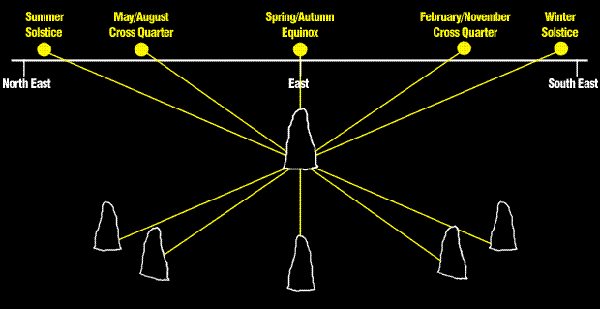
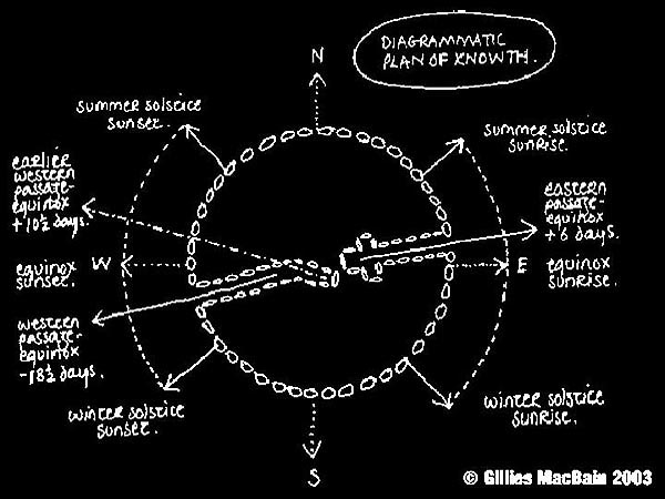
That is why hundreds
of "stone circles" are still found in the countryside all across Britain
or in other countries; because such stone circles were used by ancient
people to count seasonal or even historical time. A typical yearly
calendar based on carefully-placed standing stones is shown
schematically below (from
www.mythicalireland.com):
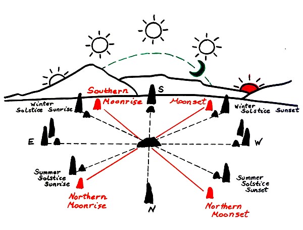
For high latitudes
such as 50 degrees North as found in Britain, our Sun rises in the
northeast on any summer solstice around June 21, but in the southeast on
any winter solstice around December 22. Then at intermediate times of
the year on March 20 (the spring equinox) or September 22 (the autumn
equinox), it rises due east and sets due west. Now if a series of tall
stones are placed carefully in the ground at proper locations, then one
tall stone (the "gnomon") may cast a long shadow from the rising Sun on
other stones some distance away, and thereby tell the "time of the year"
accurately to one or two days.
One interesting
feature of this kind of "stone clock" is that the rising Sun seems to
"move" more rapidly from day to day, when it lies close to either
equinox rather than close to a solstice. The precise angular location on
any horizon where the Sun rises is called its "azimuth", and may be any
of 45 degrees for due northeast (in the northern summer), 90 degrees for
due east (fall or spring), or 135 degrees for due southeast (in the
northern winter). Similarly, the Sun may set at 315 degrees due
northwest (in the northern summer), 270 degrees due west (fall or
spring), or 225 degrees due southwest (in the northern winter) (see
aa.usno.navy.mil/data/docs/AltAz.html).
The precise angular
height above the horizon of the Sun at any time of day is called
"altitude". At sunrise or sunset, its altitude always equals zero.
During the middle of the day, its peak altitude (due south as seen from
Britain) will depend on latitude north, and also the summer or winter
season (high or low in the sky respectively). Modern hourly sundials
often use "altitude" to the tell the time of day. But for the megalithic
field sundials to be discussed here, which only measure the rising or
setting Sun, we only need to concern ourselves with "azimuth", because
"altitude" will generally be zero.
All yearly sundials
keep time according to what is known as the "tropical year"---how long
it takes for the Sun to return to an identical location in Earth's
sky---rather than a "sidereal year"---how long it takes for the distant
stars to return to an identical location in Earth's sky. The two kinds
of year are almost but not quite identical, because the daily spin axis
of our planet processes about due north once every 26,000 years
("precession of the equinoxes"). There are two other very slow changes
of Earth's motion over historical time: (i) a slow change of its tilt
angle relative to the Sun; and (ii) a slow precession of its elliptical
orbit about the Sun, both of which become relevant when analyzing
megalithic sundials, and will be discussed briefly below.
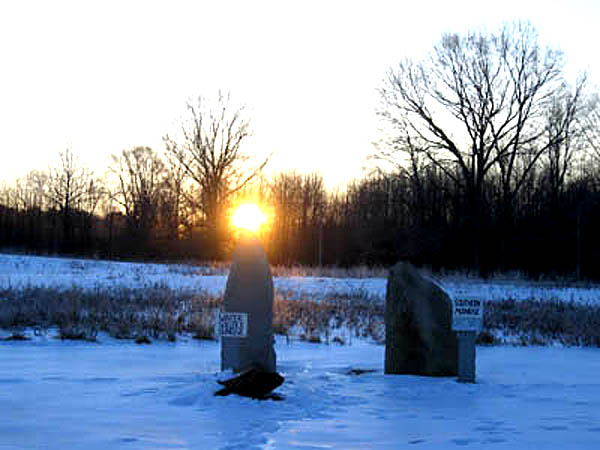
Fortunately, we do not need to worry too much about how to build a
precise, yearly observatory for the Sun out of standing stones, because
an enterprising professor of astronomy at the University of
Massachusetts, namely Judith Young, has already done so in a field near
her university! Her modern stone observatory is called the "Sun-wheel",
and two vivid pictures of how it keeps yearly time are shown below (see
www.umass.edu/sunwheel):
On the spring equinox of March 20-21, our Sun rises due east at azimuth
90 degrees. A second tall stone was placed just to the right of due east
in the photograph above, so that the rising Sun would be "framed"
between two nearby stones just after it rises and moves south (a similar
two-stone portal was used at Stonehenge). Later on the winter solstice
of December 22-23, our Sun rises in the southeast near 122 degrees at
the latitude of Boston (42 N). So now we see how such ancient sundials
would have worked; and why they still fill the rural landscape, all
across the modern British Isles.
Sunrise
geometries at Avebury 2003
But why should we
need to learn today about megalithic sundials? Personally I took little
interest in the subject, until a series of "sundial" pictures appeared
in Wiltshire fields, the most recent being Oliver's Castle of April
2007. Earlier in 2004, 2005 and 2006, the crop artists had shown other
motifs based on the ancient Mayan calendar or modern wormhole theory.
First Mayan calendars, then wormholes, and now sundials! They certainly
expect us to have a wide range of knowledge. Or could each of those
three different themes be coming from three different groups, using the
same communications device (say a buried wormhole) near Silbury Hill?
In any case, if we
wish to understand more clearly the four "sundial" pictures mentioned
above, we should start with the easiest and most straightforward, namely
Avebury of June 21, 2003:
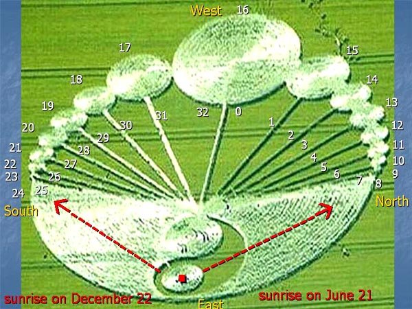
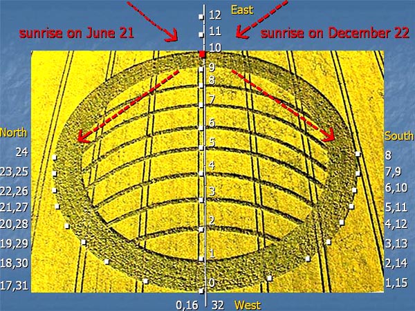
Avebury 2003 shows
an ancient and well-accepted sundial design, that has also been found on
a few stones near Knowth or Loughcrew in Ireland (see
below). Its "gnomon" or tall-shadow-casting stone is represented by a
small white circle near the bottom of the figure (labelled with a red
square), that has been embedded within a green "teardrop" shape. The
upward, counter-clockwise flow of that teardrop then represents
a north-to-west motion of the Sun's shadow upon other nearby stones, as
shown upper right to top centre (white circles "8" to "0"), when
proceeding from sunrise on June 21 to sunrise on September 22.
That same, slow,
91-day solar motion will be repeated four times within any 365-day
year; and it serves as the primary astronomical basis for an ancient
"Irish megalithic calendar", which was in widespread use throughout the
British Isles from 3500 BC to 1000 BC. Later however it fell into
complete disuse. Today it is known mainly for to its resemblance to a
modern Celtic calendar, and also due to its rediscovery by Alexander
Thom in the 1960's, when he was surveying megalithic sites all across
Britain.
For simplicity, let
us choose to begin any megalithic year on March 20 with a spring
equinox. Such a date will correspond to "0" or the large white circle at
top, when looking at a picture of Avebury 2003. Next we may count
downward to "8" as a tiny circle along the middle-right until we reach
June 21 (the summer solstice). Then we may count upward again from "9"
to 16", and so return to the large white circle at top on September 23
(the autumn equinox). Next we may count downward again, but this time on
the left from "17" to 24" until we reach a tiny white circle along the
middle-left on December 22 (the winter solstice). Finally, we may count
upward again from "25" to "32", until we return for a third time to the
large white circle at top on March 20 (the spring equinox). That was how
the megalith builders counted time 5000 years ago.
Not only are the
many different stone locations shown at Avebury 2003 approximately
correct; they are closely correct. For example, the large white circle
"0" at top has been drawn much larger than either tiny circle "8" or
"24" on left or right, because the spacing of solar azimuths becomes
much larger within any one-eighth part of a quarter-year, when the Sun
lies closer to an equinox than to a solstice.
In order to quantify
that relationship, I measured angles of solar azimuth along the
right-hand side of that picture (because the left-hand side had been
distorted through perspective), and found predicted sunrise angles of
90, 73, 63, 56, 51, 48, 46, 44, 43 degrees when proceeding from "0" to
"8". By way of comparison, true sunrise angles for latitude 58 N would
be 90, 81, 73, 65, 57, 51, 45, 42, 40 degrees. Fairly close, but one
would need a more precise measurement of those crop azimuth angles
without any influence whatsoever of photographic perspective, to make an
exact comparison.
In summary, the
ancient Irish megalithic calendar divided any 365-day year into 32 equal
parts of 11.4 days each, and that was the calendar shown at Avebury Ring
on the summer solstice of 2003.
Avebury
2003 also appears in stone at two archaeological sites in Ireland
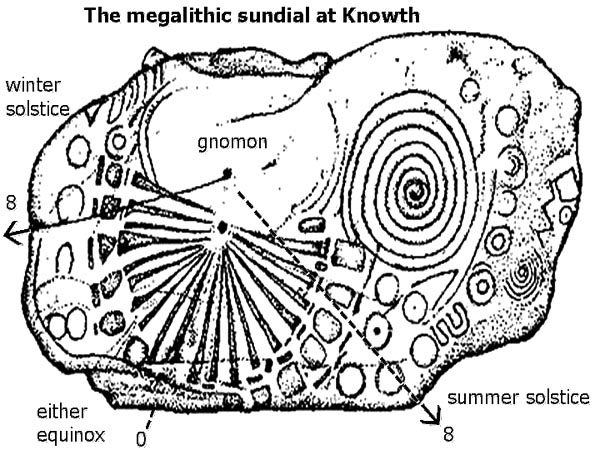
Strangely enough, a
true megalithic sundial similar to Avebury 2003 was carved onto
kerbstone K15 at Knowth in Ireland, sometime around 3500 to 2000 BC:
The stone-sundial
shown there divides each quarter of any 365-day year into eight equal
parts. In fact, a solid line was carved from its gnomon all the
way to the left-hand edge of that rock, through an intermediate
arc-triangle representing "8", to emphasize the fact. (I added a dashed
line through another "8" on the right for purposes of clarity.)
Here we see a much
more even spacing of azimuths than was shown at Avebury 2003, perhaps
because it would be hard to carve an uneven spacing into hard rock. The
total angle which any solstice sunrise "8" makes with the equinox
"0" appears in this ancient sundial to be approximately 55 degrees, as
compared with approximately 50 degrees as shown in Avebury 2003
(suggesting a slight increase of latitude to 60 N from 58 N).
A
second stone-sundial, similar to the one shown above, has also been
found at Loughcrew in Ireland.
Two broad
spirals (one large, one small) which appear on the right-hand side of
that Knowth rock are thought to represent a "large warm summer sun" or a
"small cold winter sun" respectively. As if on cue, those two spiral
symbols later appeared in crops at Fort Nelson on June 5, 2004, in
the season that followed Avebury 2003.
Sunrise
geometries at Oliver's Castle 2007
More recently on
April 15, 2007, a second "sundial" type of crop picture appeared
at Oliver's Castle north of Roundway. It was oriented precisely
west-to-east in the high hilltop field where it was found. Several tall
trees nearby cast their long shadows onto it late in the afternoon, to
give the impression of a "gnomon". Everyone could see right away that it
was meant to represent a sundial, but of what kind specifically?
That crop picture,
when viewed from above, shows a simple and elegant construction using a
series of eight overlapping circles and their intersections:
Yet this particular sundial seems harder to interpret than Avebury
2003, because it shows no fixed location for its gnomon. The precise
location of any vertical-shadow-arm or gnomon depends sensitively on
latitude. By trial and error, I found that placing a gnomon at
position "10" in Oliver's Castle (red square) would yield
satisfactory results, for the geographical location and field
orientation where it was found.
Thus, by working
from an accurately reconstructed model of that crop picture on graph
paper (made using ruler and protractor), I found that placing a
gnomon at position "10" would yield sunrise azimuth values of 50 or
130 degrees for the summer or winter solstices respectively; which
are approximately correct for latitude 51 N, and the east-west field
orientation of that crop picture as it was drawn. Actual values of
sunrise azimuth at either solstice should equal 50 and 128
degrees for latitude 51 N (Avebury), or 48 and 130 degrees for
latitude 53 N (Knowth). A slight change in the Earth's tilt over the
past 5000 years may have shifted both values slightly further east
today than in 3000 BC, but by only about one degree.
A time-dependent spacing of sunrise azimuths was likewise measured
from my reconstructed model as 90, 79, 72, 67, 63, 59, 55, 52, 50
degrees, when proceeding from outer-edge location "0" (either
equinox) to outer-edge locations "8" or "24" (either solstice).
Actual values should equal 90, 83, 76, 68, 62, 57, 53, 51, 50
degrees at latitude 51 N. Such model-dependent angular
measurements need to be further quantified, before we can draw
any detailed conclusions.
In summary,
Oliver's Castle appears to show a very general kind of sundial,
since the precise location of its gnomon was not specified. For
example, moving its currently-placed gnomon (red square) from
"10" to "11" would give suitable values of sunrise azimuth for 48
N latitude, while moving it to "12" would give suitable values
for 42 N latitude
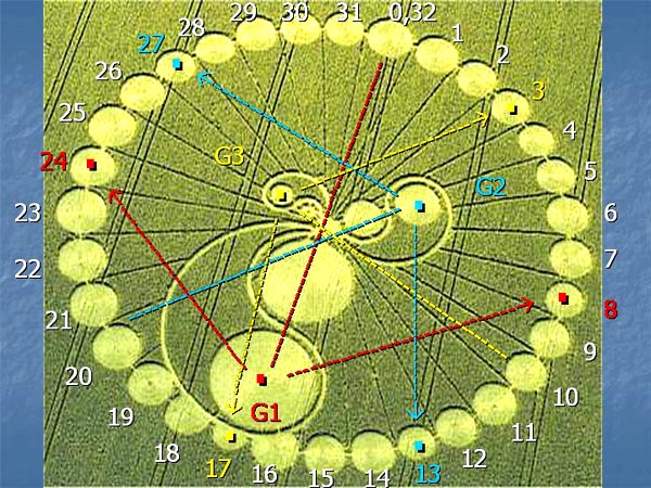
Hackpen
Hill 2003 shows a megalithic sundial with three different gnomons
Now as we begin to
analyze this third sundial, matters will become even more complex, and
we will truly begin to appreciate the high intelligence of those crop
artists! One month after the first crop picture described above appeared
at Avebury Ring, another crop picture of a similar kind appeared at
Hackpen Hill on July 20, 2003:
When looking at this
new picture, again we can see the same "small white circle"
and "teardrop" shape as shown at Avebury 2003; but now there are three
separate gnomons called G1 (red), G2 (blue) and G3 (yellow), all located
within the same sundial. Each teardrop describes the slow seasonal
motion of daily sunrise from any solstice to an equinox, as viewed along
the horizon at altitude zero. The outermost part of Hackpen Hill
likewise shows 32 separate "white circles", which would be expected for
counting yearly time by an Irish megalithic calendar.
Still, this
particular sundial shows no well-defined east, west, south or north. How
are we supposed to interpret it? Its three gnomons G1, G2 and G3 lie at
120-degree angles to one another, and also at different radii from the
centre. The entire picture would have been hopeless to interpret, had
not those always-clever crop artists given us an essential clue. Thus,
certain white balls along its outer perimeter were drawn with
slightly-smaller diameters than the others; and it is to those "small
balls" that we need to "connect the arrows", from any gnomon to its two
azimuths at the summer or winter solstice.
Having found that
essential clue, I connected G1 (red) to outer positions 8 and 24; G2
(blue) to outer positions 13 and 27; and G3 (yellow) to outer
positions 3 and 17. A few of these assignments remain ambiguous, owing
to occasional inaccuracies of drawing "small balls", but this
scheme should be approximately correct as a whole. Next, having
connected the arrows, I measured differences of solstice azimuth away
from due east as 57 degrees for G1, 55 degrees for G2, or 60 degrees for
G3; and could thereby deduce a narrow range of latitudes from 60 N to 62
N where this particular sundial would be functional. All of those
latitudes lie too lie far north for anywhere within the British Isles;
but could correspond to southern Greenland (unlikely), or more probably
southern Norway (see below). More accurate measurements would again be
useful without any photographic perspective.
A slight
offset of gnomon G1 from due east at Hackpen Hill resembles a similar
offset of the eastern passage at Knowth
Given the extreme
care with which that Hackpen Hill crop picture was drawn, I found it
remarkable that gnomon G1 (red) was placed intentionally with a slight
offset from both outer positions "16" and "17", so as to lie
essentially between them. What could this mean? The total
angular interval between "16" and "17" equals (360 / 32) = 11.3 degrees,
and so the observed offset would amount to 5 or 6 degrees away from the
equinox (due east).
Of possible
relevance here, both the eastern and western passages at Knowth were
also built with a slight offset from due east or west, with azimuths
of 85 or 259 degrees respectively. The highly advanced builders of
Knowth could hardly have included such a big offset by chance:
The Knowth site as a
whole shows fairly accurate alignments of its sunrise or sunset azimuths
away from due east by 40 to 45 degrees at either solstice, consistent
with a latitude of 53 N. Why then should its eastern and western
passages have been built with an offset from due east or west
by 5 or 11 degrees? In practical terms, sunrise enters that eastern
passage 6 days after any spring equinox, while sunset enters the western
passage 18.5 days before any spring equinox.
Some experts believe
that those offset passages were meant to measure monthly cycles of the
Moon, as well as yearly cycles of the Sun. Thus, when sunrise in 3000 BC
entered that eastern passage at an azimuth of 85 degrees, it would take
another three lunar months precisely of 29.5 days before the
Sun would reach its summer solstice. In other words, it would take
another (3 x 29.5) = 88.5 days when counting by the Moon, or (94 - 6) =
88 days when counting by the Sun. Similar calculations may be made
concerning the western passage. Quite a few other aspects of Knowth
likewise suggest that it may have been used as a lunar observatory as
well as a solar.
Now here is the
interesting part: in 3000 BC, it took 94 days to go from any
spring equinox to a summer solstice, whereas today it takes 92 days.
The reason is because Earth's slightly elliptical orbit has precessed
around the Sun by 70 degrees since then, and so any
spring-summer interval was located slightly further from the
Sun then versus now.
Therefore, if
Hackpen Hill was designed with the same broad logic as Knowth (it even
looks like Knowth: see above), then the slight offset of its gnomon
G1 from "16" towards "17" would suggest a general date of astronomical
relevance between 3000 and 1000 BC, when spring seasons on Earth were
still 94 days long. By looking very carefully, one can also see that
gnomon G2 at Hackpen Hill lies offset between "4" and "5", while gnomon
G3 lies offset between "25" and "26". Do you think they are trying to
tell us something?
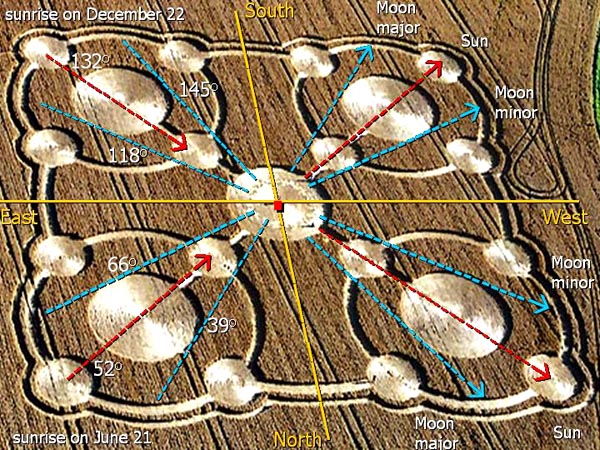
Avebury
2005 showed both solar and lunar azimuths to illustrate a
19-year astronomical cycle of the Moon
Lastly, we may close our analysis with the straightforward case of
Avebury 2005, which appeared on July 27, 2005. It showed a four-armed
Celtic cross, and included 19 secondary mini-circles within its centre
most part (close to the "red square") that were apparently meant
to symbolize a 19-year astronomical cycle of the Moon:
We can interpret this particular crop picture with ease, because an
inspired professor of astronomy at the University of Massachusetts,
Judith Young, has recently created a very similar "Sun-wheel"
observatory in a field near her university (www.umass.edu/sunwheel).
A schematic version of her modern standing-stone observatory is shown
below:
Some standing stones (coloured in black) were placed to indicate where
the Sun rises and sets, while other standing stones (coloured in
red) were placed to indicate where the Moon rises and sets. Two kinds of
stone are necessary, because our Moon rises and sets in general with a
slightly different azimuth from our Sun. That happens for two reasons.
First, when measured relative to Earth's equator, our Sun varies rather
slowly in "declination" from +23.5 to -23.5 degrees each year, whereas
our Moon varies more rapidly in declination by a similar amount each
month. Secondly, our Moon may vary in declination every month from +28
to -28 degrees maximally, or else from +18 to -18 degrees minimally.
How long does it take to switch from one kind of variation to the other?
It turns out that, once every 19 years, our Moon varies in declination
by a maximal amount of +28 to -28 degrees; whereas halfway or 9.5 years
between those two periods, it varies in declination by a minimal amount
of +18 to -18 degrees. The precise number of years required to switch
lies close to 19 when measured relative to the Sun, or 18.6 when
measured relative to the distant stars.
This is called the "Metonic cycle" of the Moon, after the Greek
astronomer Meton who supposedly discovered it Each period of maximal
(+28 to -28 degrees) or minimal (+18 to -18 degrees) declination is then
called a "lunar standstill". Any standstill is termed "major" if the
Moon rises as far as possible outside of the Sun (28 degrees) relative
to due east; or "minor" if the Moon rises as far as possible inside of
the Sun (18 degrees). Our Moon reached its last major standstill in
2005-2006, beginning around June 2005 and continuing until June 2006. It
will reach its next minor standstill in 2015. The Avebury crop picture
of July 2005 was evidently meant to illustrate the onset of that last
major standstill, beginning on a full moon only one month earlier.
Now having explained some basic astronomy, we will change our
terminology back to "azimuths" from "declinations", because azimuths
tell where the Sun or Moon will rise or set relative to any
local horizon (and depend on latitude). In Judith Young's Sun-wheel, the
maximal deviation of solar azimuths from east or west amounts to only 32
degrees at either solstice, because Boston lies at a relatively low
latitude of 42 N relative to Avebury (51 N) or Knowth (53 N). Likewise,
the maximal difference between azimuths for the Sun and Moon near
Boston never exceeds 9 degrees at either standstill, owing to the low
latitude there.
Next I
measured precise values of azimuth from that Avebury 2005 crop picture
as 52 and 132 degrees for the Sun (at either solstice); versus 39 and
145 degrees for the Moon at its major standstill (in the years 2005 and
2006), or 66 and 118 degrees for the Moon at its minor standstill (in
the year 2015). By comparison, known values of solar azimuth are 50 and
128 degrees at Avebury (51 N), or 48 and 130 degrees at Knowth (53 N).
Likewise, known values of lunar azimuth for a major standstill are 36
and 148 degrees at Knowth (53 N), or 25 and 162 degrees at Callanish (58
N).
Both solar and lunar
azimuths would therefore seem to place Avebury 2005 within a
narrow range of latitudes from 52 to 53 N. The Sun deviates there from
due east by approximately 40 degrees on either solstice; while the
maximal difference between azimuths there for the Sun and Moon is
typically 13 degrees. More accurate measurements may allow us to refine
those estimates in the near future. Finally, the precise sizes of
"balls" (large-solar or small-lunar) in Avebury 2005 were
used to specify a certain latitude of 52-53 N; but those ball diameters
could easily be changed to indicate other latitudes, so long so the
angular spacing of its four arms were likewise changed in tandem.
Alexander Thom, Martin Brennan and N.L. Thomas
We did not "invent"
most of the ideas presented here. Instead, it should be noted that
three scholars in particular: Alexander Thom, Martin Brennan, and N.L.
Thomas, worked out most of the basic ideas concerning megalithic
astronomy in the British Isles some years ago.
Alexander Thom was a
professor of engineering at Oxford. He first surveyed megalithic sites
all through Britain, and published his early results in Journal of
the Royal Statistical Society (1955). Then he published two more
articles in 1962 and 1964 which addressed megalithic units of length:
Next he went on
to discover precise solar alignments at many stone circles, which led
him to argue for a prehistoric solar calendar of 16 months (half of 32).
His proposed 16-month year contained four months of 22 days, eleven of
23, and one of 24. He explored that topic further in Megalithic
sites in Britain (1967), Megalithic lunar observatories
(1971), and Megalithic Remains in Britain and Brittany (1978).
Martin
Brennan discovered that "intensive sun-dialling" was practiced in
ancient Ireland, with techniques both scientific and advanced.
"Those were the oldest sundials in the world, and predate all others by
thousands of years." He also explained how lunar theory was developed in
the Boyne Valley, and emphasized that they were not just a people who
understood the Sun. Later he wrote The Stones of Time:
Calendars, Sundials and Stone Chambers of Ancient Ireland (1984):
More recently, Brennan has found that early Celtic explorers even made their way to western North America 2000 years ago, where they carved Ogham or Gaelic characters onto the rocks to mark a spring equinox (see "Martin Brennan at Anubis Cave equinox" on video.google.com/videoplay?docid=-1856547827596216006). . N.L. Thomas has carefully interpreted many different stone inscriptions from Knowth or other megalithic sites, as described in his 1989 book, Irish symbols of 3500 BC. . Finally, as an important addendum to such previous work, C. Knight and R. Lomas in their book Uriel's Machine (1999) argue that the ancient Book of Enoch was written somewhere in the British Isles just before the Flood (ca. 3100 BC). It describes a large megalithic observatory similar to the ones described above, except where each quarter of the year (91 days) had been divided into three parts rather than four or eight. Thus, every full year of 365 days would have contained 12 months rather than 16 or 32. Some people believe that the ancient British Isles could have been a remote outpost of a more advanced Sumerian civilization. For example, "Shamsiel" in Enoch taught "signs of the Sun", while "Shamash" in Sumeria was a "god of the Sun". Furthermore, certain recovered cylinder seals from ancient Sumeria show star-like symbols which suggest that two kinds of calendar, using either 12 or 16 months, may have been in use at the time (see "Shamash" or "Annunaki" on Wikipedia). Might some of those modern crop pictures be coming from the megalith builders themselves? In light of these new geometrical and astronomical analyses, it has become clear that the four crop pictures discussed above: Avebury 2003, Oliver's Castle 2007, Hackpen Hill 2003 and Avebury 2005, could not plausibly have been made by local human fakers.
Instead, it seems
increasingly plausible that the modern crop artists come from a culture
which is more technologically sophisticated than our own, yet
still have close links with a long-forgotten race of Irish megalith
builders known as the Tuatha de' Danaan. Their name means
literally "People of Anu" or "People of the Star-Sky". The Latin words "deus"
and "dea" for "god" and "goddess" derive from them. The English
words "Danube River" and "Denmark" also derive from them.
Most of what we know
today about the Tuatha de' Danaan comes from studying megalthic
sites, or from reading ancient legends such as those complied in the
Lebor Gabala Erren (Leinster,1150 AD): "The Tuatha de' Danann came
to Ireland in dark clouds. They landed on the mountains of Conmaicne
Rein in Connacht, and brought a darkness over the sun for three days.
Then they demanded kingship from the Fir Bolg. A battle was fought (the
first battle of Mag Tuired) in which a hundred thousand Fir Bolg
died. Thereafter the Tuatha de' Danaan took kingship of Ireland. Gods
were their men of arts, and non-gods their husbandmen".
Now according to
that same legend, the tall, fair-haired Tuatha de' Danaan were
themselves defeated in battle just 200 years later by a dark-haired
haired group of invaders from northern Spain known as "Milesians". And
as if in confirmation of the legend, modern genetic research has shown
that the inhabitants of western Ireland today near Connacht show certain
rare DNA polymorphisms within their Y chromosomal DNA, shared by no
other European people apart from the Basques.
Eachaid Ua Flainn, a
poet from 985 AD, wrote: "The Tuatha de' Danaan had no vessels. No one
knew whether it was out of the heavens, or out of the earth, that they
came. Were they even men?" According to tradition, they
had lived originally in a place called "Achaia" (possibly northern
Greece), before they spent some years in "Lochlonn" (probably modern
Norway). There they lived in "four great cities to the north" called Falias,
Gorias, Finias or Murias, and taught science or other useful skills to
the locals. Eventually they migrated to Scotland and Ireland around 2000
BC.
Some of the astronomical crop pictures discussed above seem refer to latitudes near 51-53 N, where Avebury and Knowth are located; whereas others seem to refer to a more northern range of 60-62 N, which might correspond to southern Norway. Likewise, Hackpen Hill seems to refer to a distant time in the past around 3000 to 2000 BC, when Knowth was first being built. One long-time student of the Tuatha de' Danaan, a retired geologist called Tim O'Brien, has argued that the legendary term "Achaia" might refer to "Accad" in northern Sumeria (www.goldenageproject.org.uk/whodunit.html) where a group of advanced scientists once lived. After the collapse of that city in 2100 BC, did those scientists migrate elsewhere? Just after the Flood (ca. 3100 BC), a frantic period of mound building began in low-lying areas all around the world, so that people would have somewhere safe to go if the flood waters returned. Silbury Hill was built for example during that period. By legend, Ireland was swept clear of any inhabitants for 300 years. Only by 2800 AD did a series of "invaders" once again begin to inhabit Ireland, as documented in the Lebor Gabala Erren. The Tuatha de' Danaan ("People of Anu") were supposedly the fourth of these, sometime around 2000 BC. Having left Accad in Sumeria after its fall (or perhaps Achaia in Greece), they would have had to travel first over land to Norway, and then later across the sea to Scotland and Ireland. It may have seemed logical for them to migrate to a relative place of safety such as the ancient British Isles, since their own ancestors ("Uriel" and "Shamsiel") seem to have had bulit megalithic sites there, one thousand years earlier. Now the Tuatha de' Danaan who emigated to Ireland were reportedly tall, fair-skinned blondes or redheads with blue or green eyes. They dramatically upgraded the local Irish gene pool by interbreeding, so as to create the Celtic-Gaelic race we see today. St. Patrick recorded how one of their pure-bred women married an Irish king in 400 AD. They made the golden torc, and could move heavy stones with ease. But where did they come from originally? How did they reach Ireland by air? What kinds of technology might they have brought with them? And why do so many modern crop pictures appear near their ancient sites of settlement, often showing Celtic or even sundial-type astronomical motifs? Red Collie
Supplementary material
A table of solar solstice azimuths
A table of lunar standstill azimuths
|