|
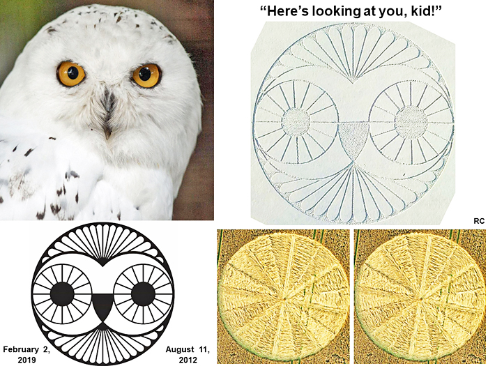
THE SNOW OWL OF ROUNDWAY HILL ¢ OliverÆs
Fort, nr Devizes
1 of 3- Page 4 Sketch Map
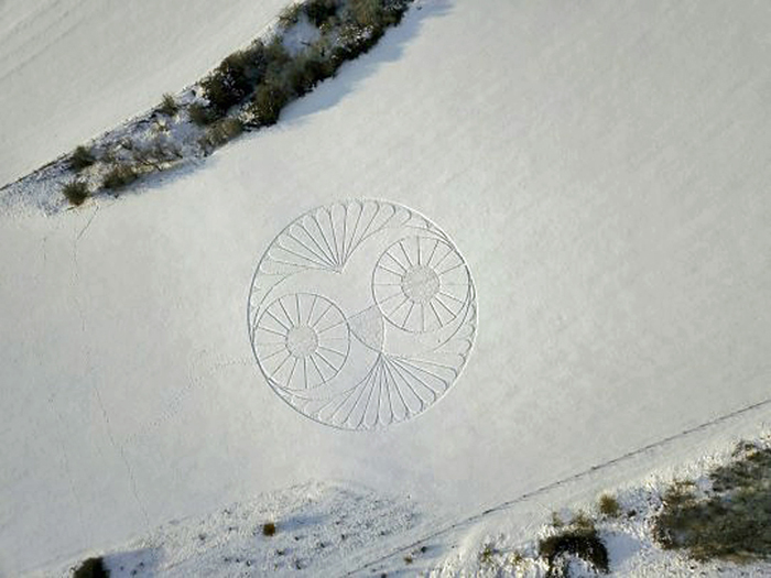
On 2nd
of February 2019, Chris Barrow, a civil servant, reportedly out taking
pictures of the snowy landscape with his drone, came across a large
design that had been created in fresh snow just to the north of Roundway
Hill near Devizes. Using his drone he took photographs of the design
which were later reported on Metro, other internet sites and featured on
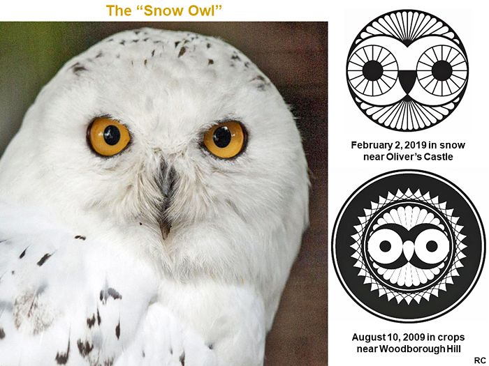
the Crop Circle Connector website as the design, called the Snow Owl,
closely replicated very similar owl images that had been created in crop
circles in previous years. It has been suggested that whoever created
the owl crop circles may have also managed to create the Snow Owl or
that the crop circles were an inspiration for the later snow formation
at the beginning of February 2019. This, of course, assumes that the
video taken is genuine and not a fake creation by photo trickery.
Crop Circle Rumours 2019
A study of the crop formations
that appeared in 2018 has shown that many of them flag ancient sites and
routes of southern Britain and were often placed in locations where crop
formations had appeared in previous years. All this is detailed in a
separate account. To discover this connection to an ancient layout of
sites, often considered sacred, and the ancient routes of Britain, one
needs to consider the Latitudes and Longitudes of the crop formations
that appeared in 2018. So it follows that it is of great interest to any
researcher where exactly crop formations may appear this year, 2019, to
see if some of them might also conform to this ancient layout. February
is too early in the year for crop circles but we have this, possibly
crop circle inspired, Snow Owl design to consider. Was it just created
at random on the landscape or was it also formed in a specific
geographical position for a reason, or maybe several reasons, whoever
may have created it ?
Here are a few suggested reasons
as to why the Snow Owl was created at the given location, about Latitude
51.383 degrees north of the Equator and 2.003 degrees west of the
Greenwich Meridian, an ancient and some believe possibly sacred
north/south line
...o...
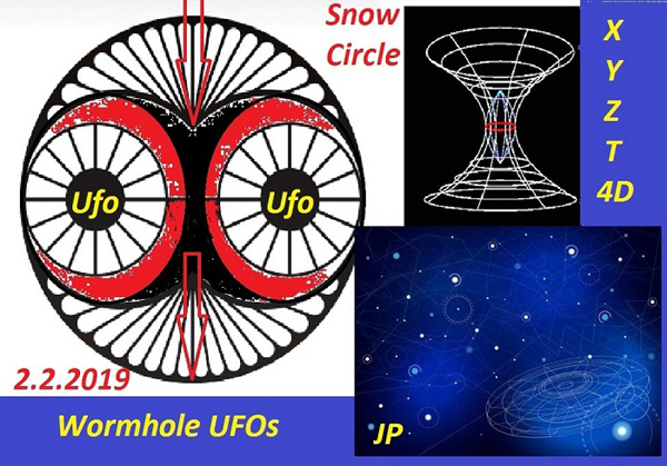
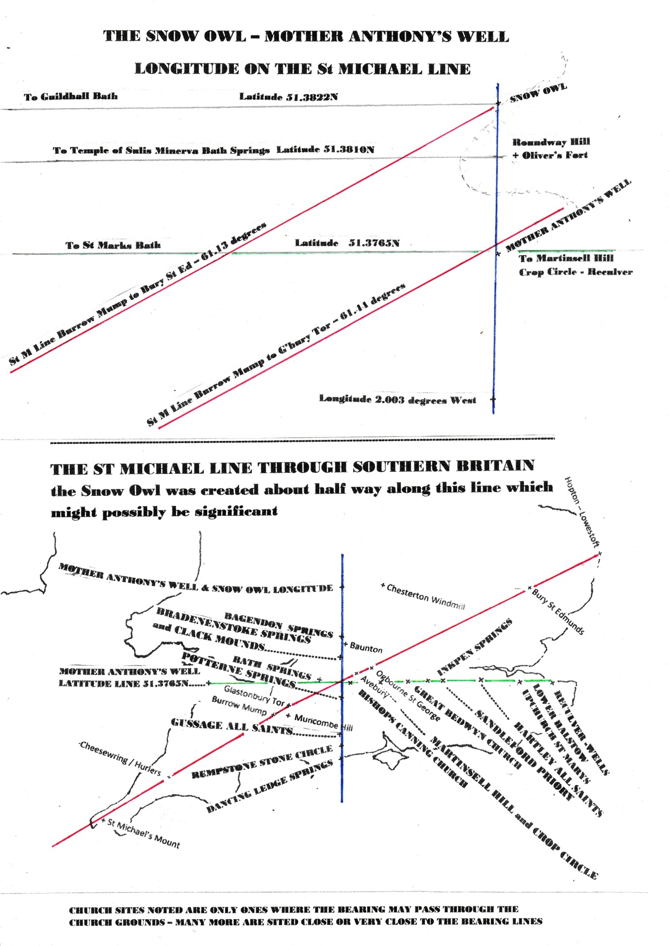
The Roundway Snow Owl was placed
on, or right next to, John MichellÆs Saint Michael Line which goes
through southern Britain from Lands End to the North Sea near Hopton /
Lowestoft. Well established St Michael Line sites tell us this. The
Great Circle bearing from the ruined St Michael church on Burrowbridge
Mump to the ruined St Michael church on Glastonbury Tor is about 61.44
degrees from True North and on the Snow Owl longitude, i.e. due south of
the snow formation, this passes just to the south of Roundway Hill and
next to an ancient sacred spring site called Mother AnthonyÆs Well. A
known Romano British site this is now believed to have origins at least
as far back as the Late Bronze Age. (www.bacas.org.uk)
The St Michael Line has slight
variations so taking a bearing again from Burrowbridge Mump this time to
Bury St Edmunds gives a bearing of about 61.13 degrees which at the Snow
Owl longitude passes right next to this snow formation, a tiny fraction
to the south. This bearing passes at about latitude 51.382 north and the
Snow Owl is recorded at 51.383 north, this might be nearer 51.3822 from
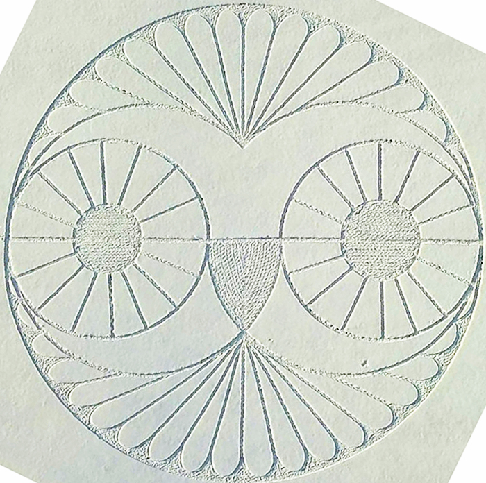
Google Maps. The axis of the Snow Owl replicates this line marked by
foot prints in the snow.
It
can be shown that crop circles which were created during 2018 often flag
locations on the St Michael Line by their Latitudes and Longitudes. The
Snow Owl is not on any of the 2018 crop circle latitudes but Mother
AnthonyÆs Well certainly is. This ancient sacred Well has a latitude of
51.3765 which is the same as the recorded latitude of a crop circle
which was created at Martinsell Hill near Wooton Rivers on 7th
of July 2018. This crop formation was destroyed by the farmer soon after
it was found but fortunately photos were taken before this happened and
its position recorded (see Crop Circle Connector website ¢ 2018 Crop
Circles)
The
Martinsell Hill crop circle was a spectacular design as noted by Lucy
Pringle and Michael Glickman, leading experts on the crop circle
phenomena. Its latitude marks Mother AnthonyÆs Well or spring right next
to the St Michael Line, the longitude of this sacred spring is marked by
the Snow Owl location found and photographed by Chris Barrow on 2nd
February 2019. With this correlation of information provided by these
amazingly clever landscape formations or designs, in crops and in snow,
anyone even remotely interested in crop circles would surely have to ask
themselves, if this is not a coincidence, why is our attention being
possibly drawn to Mother AnthonyÆs Well? Is there something special
about that particular geographical location apart from the fact that it
has very ancient origins and seems to be a marker place on John
MichellÆs St Michael Line?
We
know that Mother AnthonyÆs Well (MAW) may have been an important
location back at least as far as the Late Bronze Age, some 3,000 years
ago, and that the Romans built there some 2,000 years ago. Like many
springs in ancient folklore the MAW spring was considered sacred. Since
latitudes and longitudes are important to crop circle positions, and
maybe also to the Snow Owl position, it is worth looking at these lines
from MAW to see if they give any clues as to why it might be important -
Longitude N ¢ to the north of MAW the line highlights Calne, with an
ancient mound from at least the Iron Age, Bradenstoke with sacred
springs, a Holy Well and earthwork mounds of ancient origin. This was
later a very important priory site much favoured by early English
monarchs. Going north again the line goes to Bagendon springs which was
an important centre of the Dobunni tribe in pre-Roman times.
Archaeological reports show this was a major settlement with many
earthworks and 7 springs. The scholar Stephen J Yeates wrote of the
Dobunni people in his book æThe Tribe of WitchesÆ
Longitude S ¢ to the south of MAW the line highlights Potterne, known as
æThe Place of SpringsÆ, Dinton at Wick Ball Camp an Iron Age or earlier
site, Gussage All Saints church site, Witchampton - a river site with
Roman finds, Rempstone Stone Circle site and reaches the South Coast at
Dancing Ledge where there are several springs noted on the Ordinance
Survey
Latitude E ¢ to the east of MAW the line highlights Bishops Canning
church, Rybury Fort, Tan Hill stone circle site, Martinsell Hill Fort,
Great Bedwyn church, Inkpen springs, Sandleford Priory, All Saints
church Hartley, Upchurch St Marys, Lower Halstow - with Holy Well and
through to Reculver near Herne Bay on the east coast which has finds
dating back to the Bronze Age, Iron Age and a major Roman base.
Archaeologists found an inordinately large number of water cisterns or
wells there some may have had pre-Roman origins. How much did the Roman
invaders, or some of them, learn about ancient and clearly important
sites in Britain and then decided to reuse them?
Latitude W ¢ to the west of MAW this latitude line goes to Melksham, the
centre of Bath, then just south of Cadbury Hill Fort before reaching the
coast of the Severn estuary north of Weston super Mare. The most
interesting site on this latitude line west of the MAW spring is Bath
with its famous thermal springs which in pre-Roman times were sacred to
the Goddess Sul. The MAW latitude line passes just south of the Roman
Baths and the Snow Owl latitude line passes just north of the springs
Archaeological evidence shows that the Goddess Sul was worshipped at the
hot springs of Bath long before the Roman invasion of Britain and was
clearly thought so important to some of the Romans that they followed
her name with the name of their Goddess Minerva and worshipped Sulis
Minerva at the sacred site where the hot waters of Sulis, Aquae Sulis,
came to the surface of the country they called Britannia, another name
for the Goddess
The hot springs of Bath are unique in the British Isles, the only place
where really warm water reaches the surface of the land without cooling
on the way up from the great depths where it was heated. There are
apparently three springs that do this around the site of the Roman Baths
and the Temple to the Goddess Sulis Minerva, at a latitude of about
51.3810 north of the Equator. With the Snow Owl formation at latitude of
about 51.383, or maybe nearer 51.3822, and Mother AnthonyÆs Well at
latitude 51.3765 on that longitude the Hot Springs of Bath latitude line
goes to the centre of the fort on Roundway Hill called OliverÆs Fort and
there are also ancient barrows that mark this latitude just to the west
of the fort
It
might just be coincidence that we find other ancient Springs and Wells
north, south and east of MAW but some of these were known to be sacred
sites as folklore tells us many springs and wells were considered to be
in ancient times. Many sacred sites, later church sites, have springs
nearby.
If
the Snow Owl was intended to guide us to the MAW spring at the St
Michael Line and the ancient sacred spring site of the Goddess Sul at
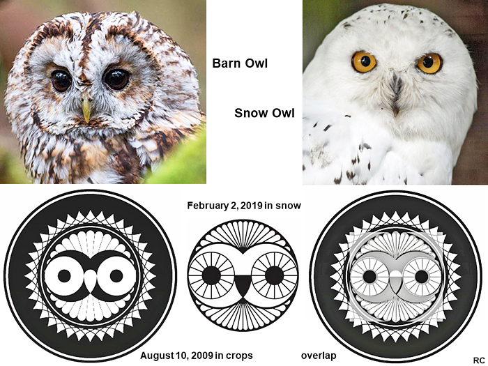
Bath, why was the design based on the owl?
When the invader Romans chose to link the Goddess Sul to their Goddess
Minerva they must have learnt from some of the Celtic tribes of Britain
that Sul was a wise Goddess which is how they viewed Minerva. Minerva
apparently derives from the Greek Goddess Athena and the sacred animal
or creature of these two goddesses was the Owl. The Owl is depicted on
finds from ancient Bath.
https://www.romanbaths.co.uk/news/minervas-owls-bath-2018.
NB - the fact that MinervaÆs Owl was featured in the 2018 trail must, of
course, be just a coincidence
Also worth noting is that the Roundway Hill Snow Owl was apparently
found and filmed on 2nd
of February 2019 and no one saw it being created so that may have been
at night on 1st
February. The 1st of February is the ancient festival of Imbolc sacred
to the Goddess Brighde . Many experts believe this Goddess, with various
spellings of her name, is the origin of the later Saint Brigid
So
whoever created the Snow Owl at Roundway Hill this year may have known
the significance of the place they chose to form it. Or was it just a
random choice, a place with a nice fall of fresh cold snow to play with?
If the video footage is correct it was an amazing achievement whoever
made it!
Mike Stewart April 2019
SKETCH MAP
|