|
A third “map
of the night sky” involving Mars, Antares and Saturn was drawn using
fallen crop and nearby landscape features at Wessex Ridgeway on July 16,
2016
We were
unable to understand what a simple “circle and dot” crop picture, which
was drawn at Wessex Ridgeway on July 16, 2016, might be trying to tell
us, until two other crop pictures and landscape features of similar
“triangular” shape appeared in early to mid-August of 2016, not far away
at Etchilhampton or Nursteed Farm.
Two “maps of
the night sky” for Saturn, Mars and Antares appeared at Etchilhampton on
August 8, or at Nursteed Farm on August 17, 2016
On August 8,
2016 at Etchilhampton, we saw the first of these “triangular” shapes. It
represented a partial “map of the night sky”, and was drawn using fallen
crop in combination with nearby landscape features (two “ghost” crop
pictures from 2015). This “field triangle” described the relative
locations of Saturn, Mars and Antares in Earth’s night sky on a date of
August 22, 2016, several weeks later (see
Etchilhampton articles).
Then on
August 17, 2016 at Nursteed Farm, we saw the second of these
“triangular” shapes. It represented another partial “map of the night
sky”, and was drawn once again using fallen crop in combination with
nearby landscape features (two large clumps of trees). That “field
triangle” described the relative locations of Saturn, Mars and Antares
in Earth’s night sky on a date of August 26, 2016, slightly more than
one week later (see
nursteed articlesl).
A third “map
of the night sky” for Saturn, Mars and Antares appeared at Wessex
Ridgeway on July 16, 2016
With these
two new crop pictures in mind, we re-examined the original “triangular”
shape which had appeared at Wessex Ridgeway on July 16, 2016 (see
wessex ridgeway comments). Now we found easily that such a “circle
and dot” in the fallen crop described “ringed Saturn” in Earth’s night
sky on a date of July 18, 2016, just two days after the crop picture
appeared:
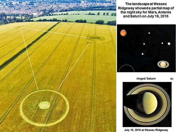
Two nearby
“knolls” in the landscape represented “Mars” or “Antares” on the same
date of July 18, as determined by matching the shape of this
crop-landscape “triangle” with the relative locations of those three
bright objects in Earth’s night sky, using a computer program (see
www.fourmilab.ch/yoursky). A more directly-overhead view of this
crop-landscape “triangle”, and its match to three bright sky objects, is
shown in the slide below.
Some
excellent field reports by Eva-Marie Brekkesto or Peter Tadd suggest
that this simple “circle and dot” crop picture was not man-made (see
wessex ridgeway field reports).
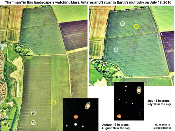
The
landscape image of a “man” who is watching the night sky
Two of those
“triangular” shapes on July 16 or August 17 were drawn within the large
landscape image of a “man”, who seems to be looking at the city of
Devizes nearby (see
nursteed articles). When we studied this landscape feature more
closely, to see exactly where the July 16 “sky map” was drawn, we found
that “Mars” was located directly over the “eye” of that “man”, while
“Antares” and (yellow) “Saturn” were located (or drawn) in his “mind”:
“Saturn” was
drawn as a “ring and dot” on July 16 at Wessex Ridgeway, “Mars” was
drawn as an “isocursal hexagram” at Etchilhampton on August 8, while
“Saturn” was drawn as “Metatron’s Cube” on August 17 at Nursteed Farm.
The other
“planetary” or “star” images were all landscape features: whether the
“ghosts” of previous crop pictures from 2015, or natural knolls in the
landscape, or large clumps of trees.
There is no
doubt that all three of these crop pictures were designed from a high
aerial perspective, and are perhaps meant to be seen from space, since
those “triangular” shapes cannot be seen easily from the ground.
A real
photograph of Saturn, Mars and Antares in Earth’s night sky on August
20, 2016
In summary,
this “man” (the mysterious crop artist) seems to have been watching a
triangular sky configuration for Saturn, Mars and Antares from at least
July 16 to August 17, 2016. We see “sky maps” drawn in the landscape on
a fairly regular basis when study crop pictures. For example, most of
the early crop pictures from 1989 to 1993 were “sky maps” (see
time2007f).
During the
summer of 2012, we saw a series of crop pictures which described a
“Martian triangle” of planets and stars in our night sky, just before
NASA Curiosity Rover was about to land (see
mars-rover-landing-night-sky-trianglel). During the summer of 2013,
we saw a “sky map” drawn in fallen crops (plus landscape features) at
Hackpen Hill, to describe the occurrence and sky location of a bright
stellar nova (see
nova-delphinus-star-explosion-naked-eyel).
Perhaps the
crop artist just enjoys watching Earth’s night sky? Or perhaps he is a
“time traveller”, who makes these “marks” on the surface of the Earth in
order to date certain events, or to document certain timelines?
In order to
gain a better understanding of this subject, I photographed the Mars-Antares-Saturn
“triangle” on August 20, 2016, four days before those three sky objects
would come into linear alignment with one another:
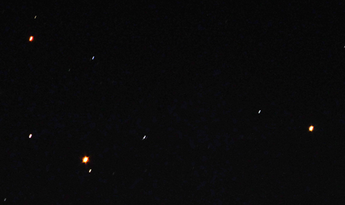
On August
20, the angle between those three sky objects was about 110o.
Mars is the large red object at lower left, while Saturn is the yellow
object on the right. Antares is a bright red star in the constellation
of Scorpio, and may be seen at upper left. Mars moves through Earth’s
sky more rapidly than Saturn, while Antares does not move (relative to
other stars) at all.
Whether our
crop-artist friend just enjoys watching the night sky, or is using those
three bright sky objects to provide “universal calendar dates” for his
time-travel adventures in the year 2016, remains to be determined.
Three radio
towers near a “grey alien” crop picture at Reigate Hill on July 19, 2016
may represent “Antares, Mars and Saturn” lined up relative to one
another in Earth’s night sky on August 23-24, 2016
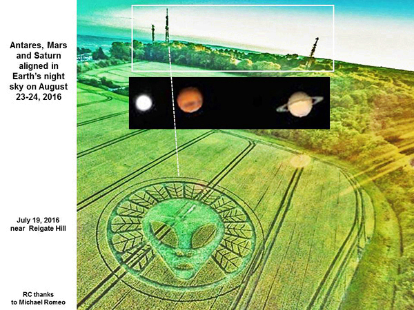
This “grey
alien” crop picture points directly at the radio tower which represents
“Mars”.
Red Collie
(Dr. Horace R. Drew)
P.S. Thanks
to Michael Romeo for several computer-generated images of the night sky
as shown in slides above. |