A
spectacular crop picture at Manton Drove on May 24, 2015 showed
repeated and unmistakeable codes, of both an astronomical and
geometrical nature, in order to suggest a near-future day and hour
of May 29, 2015 at 12 noon, when the volcano Mount Shindake exploded
unexpectedly in southern Japan
A new
crop picture appeared near Manton Drove in southern England on May
24, 2015, close to where a “polar clock” had appeared in crops three
years earlier on June 2, 2012.
This new
crop picture also shows the general shape and form of a “polar
clock”. Yet its details seem much more complicated than for the
previous example, which supplied a known date of August 5, 2012, for
when NASA Curiosity Rover would land on Mars. What might the new
“polar clock” from 2015 tell us?
A zodiac
with 13 constellations rather than 12
It seems
generally to be based on the concept of our night sky as a “wheel of
stars”, which rotates along 13 different constellations of the
zodiac:
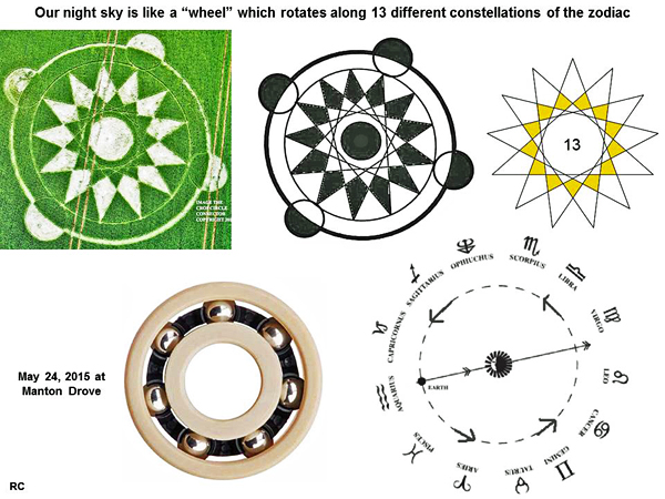
We used
to count 12 constellations in the zodiac, but now we count 13 by
including Ophiuchus:
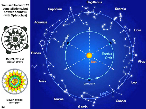
The use
of a 13-constellation zodiac also allows this crop picture to
specify an overlapping date in the Mayan Long Count calendar, which
read “13.0.2.8.2” on May 24, 2015.
Our Sun
near the centre of Taurus on May 29, 2015
On May
29, 2015 at 12 noon, which is the day and hour specified by this new
crop picture, our Sun was located near the centre of a constellation
Taurus (the Bull), which counts as constellation number 3 out of 13,
in this particular definition of the zodiac:

The
zodiac is essentially a “wheel of stars” which rotates about Earth’s
north or south poles, as a kind of “polar clock”. Technically we are
referring here to the “celestial” north or south poles, not to our
“geographical” north or south poles, but that is a detail which does
not need to be discussed further in the present context.
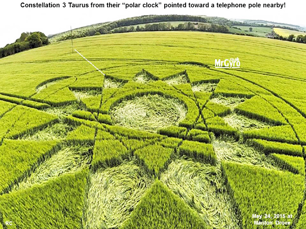
Their
“polar clock” points toward a telephone pole
Now when
we look to see how this new crop picture was drawn in the field, we
learn somewhat amusingly that “constellation 3” or Taurus from their
zodiac points toward a nearby telephone pole!
Four
telephone poles in the shape of a right-angle triangle
When we
look somewhat more broadly in the local landscape, to inspect where
this new crop picture was drawn, we can see a total of four
telephone poles nearby. These seem to be arranged in the shape of a
right-angle triangle:
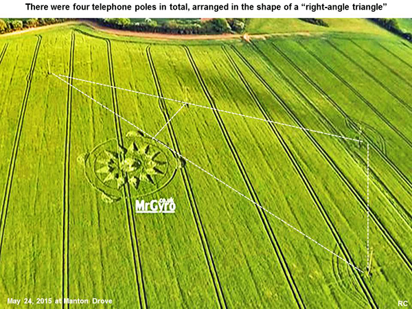
The crop
picture is a large “wheel” or “circle”, which lies tangent to the
hypotenuse of that “field triangle”, and close to its bisector.
A
special “5-12-13” right-angle triangle
Using
Google Earth, we measured angles and lengths between those four
telephone poles and the crop picture more accurately. By doing so,
we found that those four telephone poles define a special shape
known as a “5-12-13” right-angle triangle:
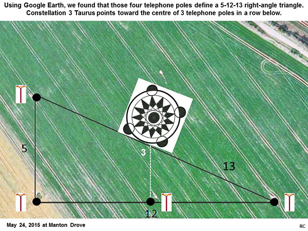
Constellation “3” or Taurus from their zodiac points toward the
centre of 3 telephone poles in a row below, along the triangular
side of length “12”.
Triangular geometry suggests a date and hour of May 29 at 12 noon
Because
this result seemed so important, we drew it again in a clear line
diagram. There are three conclusions here of a geometrical kind.
Firstly, four telephone poles define a “5-12-13” right-angle
triangle:
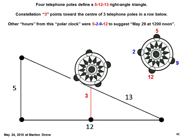
Secondly, constellation “3” or Taurus points toward the centre of 3
telephone poles in a row below.
Thirdly,
the other “hours” from this “polar clock” read as “5-2-9-12”
to suggest a date and hour of month 5 (May), day 29, and hour 12
noon. Hours “2” and “5” lie tangent to the hypotenuse of this
triangle, and suggest a number “25” which is the sum of its two
sides 12 and 13.
Rolling,
rolling, rolling on the “sky river”
In the
context of a “stellar zodiac”, we can imagine that our Sun is
“rolling along” the hypotenuse of that triangle, from constellation
2 (Aries) to constellation 3 (Taurus) and so on:
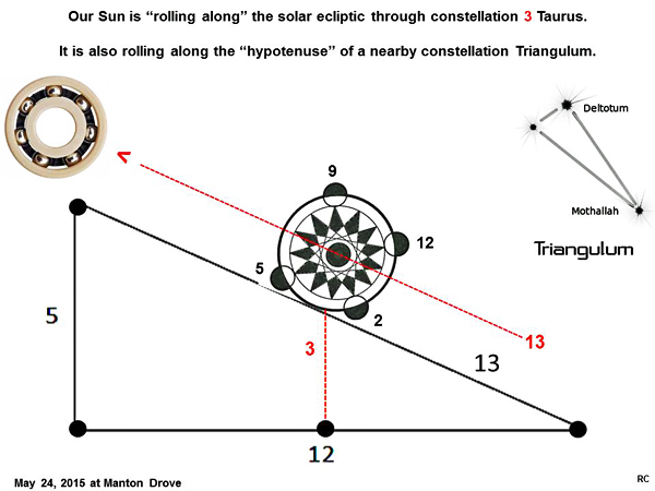
There
are 13 constellations in the complete zodiac, while side “13” forms
the hypotenuse of a “5-12-13” field triangle. Hour “13” from the
“rotating zodiac” lies parallel to side “13” as expected.
Another
constellation nearby is Triangulum, which lies just above Aries and
Taurus, and has the approximate shape of a 5-12-13 triangle. Its
“hypotenuse” also lies parallel to the solar ecliptic in Earth’s
night sky.
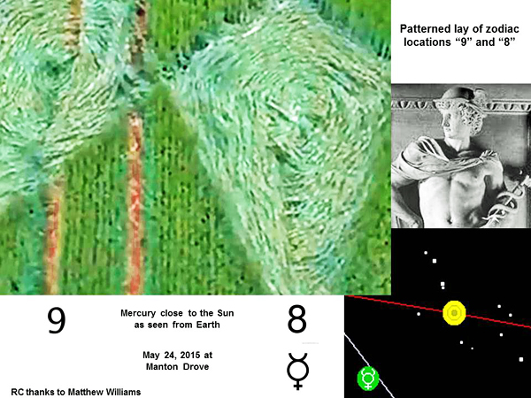
Our Sun,
Mars and Mercury formed a “right-angle triangle” in the sky on May
30, 2015
Another
possible source of triangular geometry might be a “sky triangle”
which was formed by our Sun, Mars and Mercury on May 30, 2015 at
1649 UT:
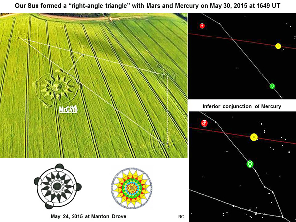
This was
when Mercury reached inferior conjunction between Earth and Sun.
Planet Mars was located on the far side of our Sun away from Earth.
Four
stars created a “clock shape” around our Sun on May 29, 2015 at 1200
UT
Just to
confirm that date of May 29, 12 noon in another way, we noticed that
four bright stars formed a “2-5-9-12” clock shape around our Sun at
that time, as it moved along the ecliptic:
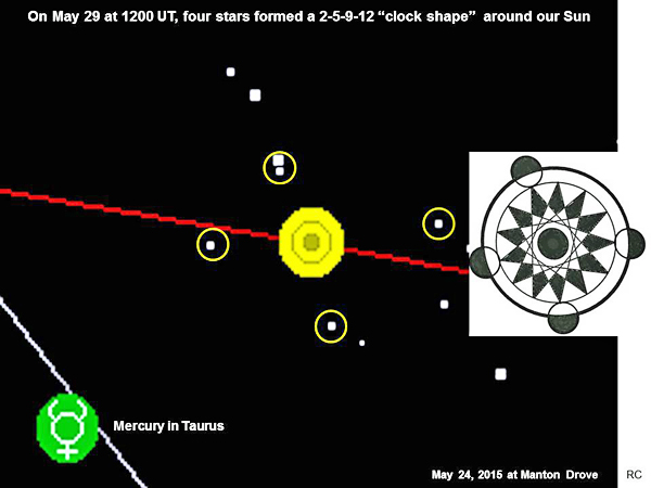
There
were not any other similar star clusters nearby on related dates.
The
astronomy of our Moon and Mercury
To be
complete, we note here that our Moon reached first-quarter phase on
May 26, 2015, two days after the crop picture appeared:
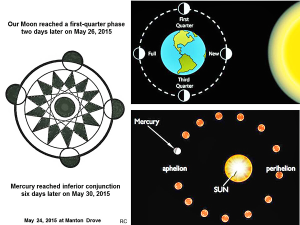
Mercury
reached inferior conjunction on May 30, 2015, six days after the
crop picture appeared.
A Mayan
calendar date of “13.0.2.8.7” for May 29, 2015
If we
were not clear in our minds already, which date this crop picture
might specify, the crop artists kindly told us in yet another way,
by using coded symbols from the Mayan Long Count calendar:
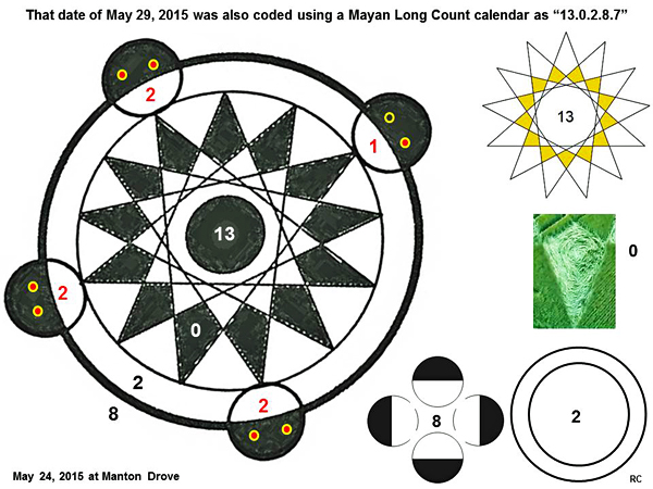
We can
read its date of appearance as “13.0.2.8.2” or May 24, 2015, just by
looking at hour “12” on the left. Alternatively, we can read its
target date of “13.0.2.8.7” or May 29, 2015, by counting little sets
of “eyes” in all four hours “2, 5, 9, 12” along its outer perimeter.
What
happened on May 29, 2015 close to 12 noon?
What was
so important about the date of May 29, 2015 near 12 noon? Well, on
that date at that hour, a dormant volcano called Mount Shindake
erupted suddenly and unexpectedly in southern Japan (see
www.youtube.com or
japan-volcano-evacuation):
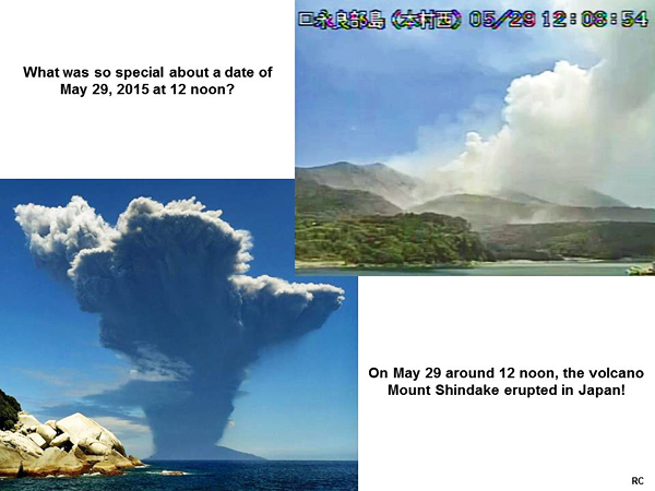
Could
this be what the crop artists (as time travellers) were trying to
tell us, five days earlier at Manton Drove on May 24?
“Volcano” symbolism” in the landscape near Manton Drove on May 24,
2015
In order
to address that question, we studied more carefully the general
landscape near Manton Drove, where the crop picture was drawn.
Indeed, we found immediately a series of images which suggest
“volcanic explosion”:
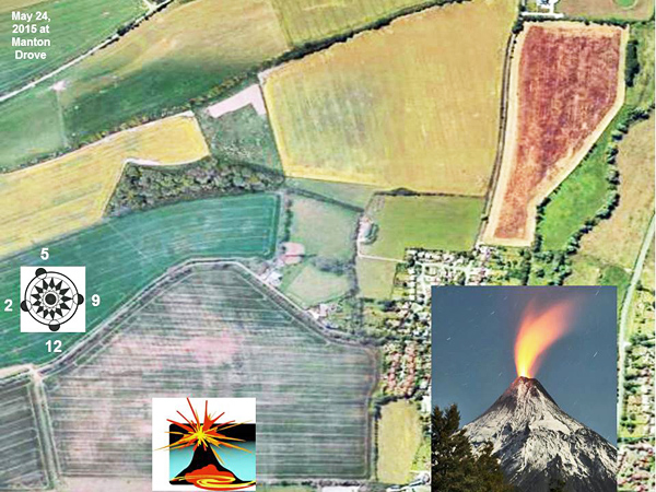
The crop
picture was drawn as shown schematically above, and reads clearly “5-29-12”
when going from left to right, or from top to bottom.
Looking
at the landscape just below, we can also see the image of a
“volcanic pipe”, through which hot magma travels upward from deep in
the Earth to be ejected above:
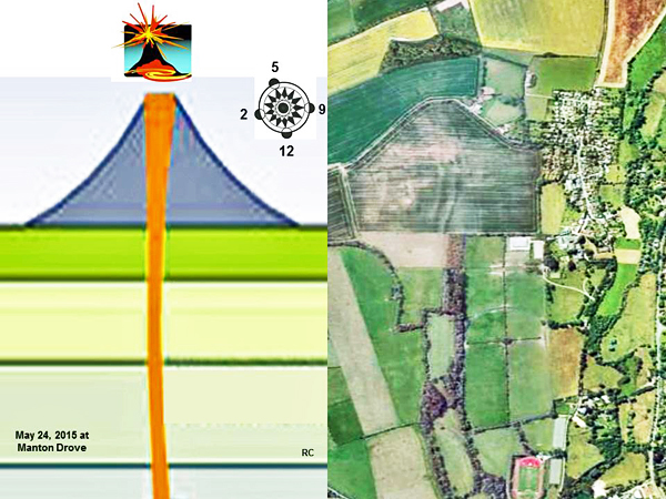
The crop
“polar clock” reads “5-29-12”, or exactly when Mount Shindake
exploded.
That
Manton Drove crop picture was apparently a “mark” made by time
travellers in order to denote an important historical event in our
local timeline. It was also drawn clearly and simply enough, so that
everyone should now be aware of their existence, unless you are
truly “blind”.
Red
Collie
(Dr. Horace R. Drew)
P.S. We
would like to thank Mr. Gyro and Matthew Williams for excellent
drone videos of this important crop picture.
Appendix
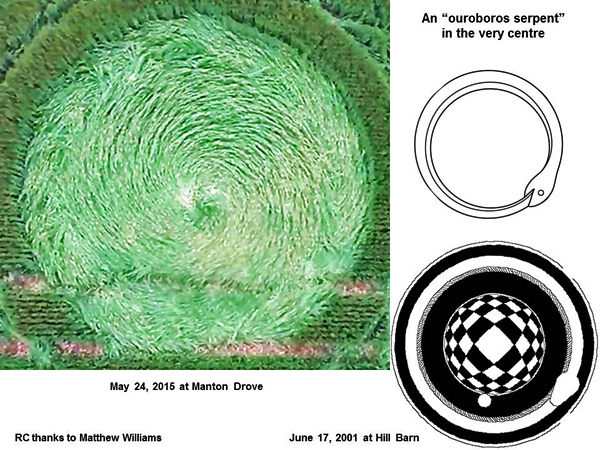
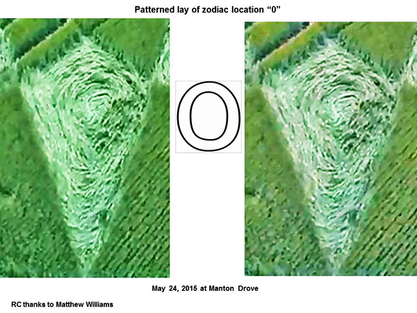
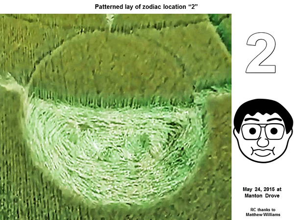
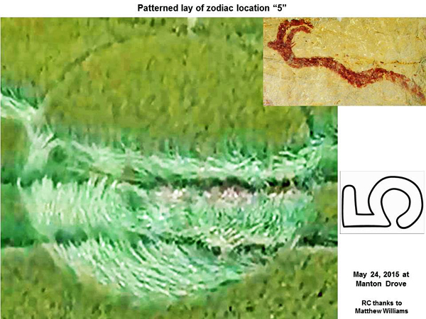
1. Various patterned lays in flattened parts of Manton Drove on May
24, 2015
Some of
the patterned lays in this crop picture were so interesting, and so
far beyond what any local humans could create using ”rope and
boards”, that we thought it would be important to document them
here.